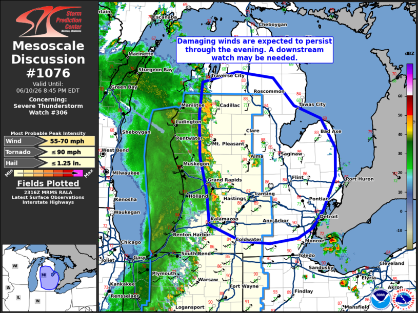
MD 1076 CONCERNING SEVERE THUNDERSTORM WATCH 306… FOR MUCH OF MICHIGAN
Mesoscale Discussion 1076
NWS Storm Prediction Center Norman OK
0618 PM CDT Wed Jun 10 2026

Areas affected...much of Michigan

Concerning...Severe Thunderstorm Watch 306...

Valid 102318Z - 110045Z

The severe weather threat for Severe Thunderstorm Watch 306
continues.

SUMMARY...Damaging winds are expected to persist through the
evening. A downstream watch may be needed.

DISCUSSION...A mature squall line continues to move across Michigan
this evening. An unstable airmass is present ahead of this line with
2000 to 2500 J/kg MLCAPE (per SPC mesoanalysis). This line is
appears to be becoming more outflow dominant through time as it
moves east of the stronger mid-level flow. However, given the
unstable environment, and some strengthening of the low-level jet
this evening, this line of storms could continue east of Severe
Thunderstorm Watch 306. If this line of storms appears to remain
severe as it moves east, a downstream watch may be needed.
Additionally, storm activity is being monitored in Gratiot County.
If this storm continue to intensify, a downstream watch may be
issued in the relatively short term.

..Bentley/Smith.. 06/10/2026

...Please see www.spc.noaa.gov for graphic product...

ATTN...WFO...DTX...APX...IWX...GRR...

LAT...LON   41978484 42248558 42818566 43428583 44148586 44708578
            44898495 44798410 44308360 44088297 43578262 43078263
            42518293 42198318 42018352 41928417 41978484

MOST PROBABLE PEAK TORNADO INTENSITY...UP TO 90 MPH
MOST PROBABLE PEAK WIND GUST...55-70 MPH
MOST PROBABLE PEAK HAIL SIZE...UP TO 1.25 IN
Source link