| Mesoscale Discussion 1071 | |
| < Previous MD Next MD > | |

|
|
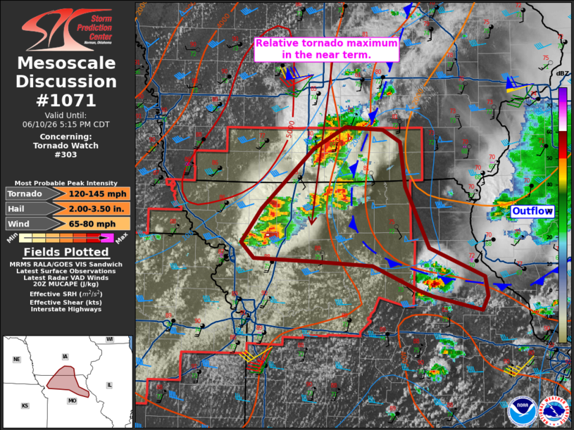
Mesoscale Discussion 1071 NWS Storm Prediction Center Norman OK 0350 PM CDT Wed Jun 10 2026 Areas affected...northern Missouri and south-central Iowa Concerning...Tornado Watch 303... Valid 102050Z - 102215Z The severe weather threat for Tornado Watch 303 continues. SUMMARY...Greatest tornado chances including strong tornado potential is currently over far northern Missouri into south-central Iowa. A strong tornado is possible. DISCUSSION...Supercells have developed within the instability axis and along the western fringe of the previous rain-cooled air mass. This air mass has recovered as expected over the last few hours with ample sunshine and 70s F dewpoints. 0-1 SRH on the order of 150 m2/s2 along with a very unstable air mass will continue to support a tornado risk for several hours as storms move across the recovering outflow area. As long as storms remain discrete, a few tornadoes appear probable. ..Jewell.. 06/10/2026 ...Please see www.spc.noaa.gov for graphic product... ATTN...WFO...LSX...DVN...DMX...EAX... LAT...LON 39759452 39929471 40299443 40949370 41169325 41149272 41009248 40529241 39879209 39559132 39359127 39209136 39349203 39409223 39689287 39729374 39759452 MOST PROBABLE PEAK TORNADO INTENSITY...120-145 MPH MOST PROBABLE PEAK WIND GUST...65-80 MPH MOST PROBABLE PEAK HAIL SIZE...2.00-3.50 IN |
|
|
Top/All Mesoscale Discussions/Forecast Products/Home |
|
Source link