| Mesoscale Discussion 1062 | |
| < Previous MD | |

|
|
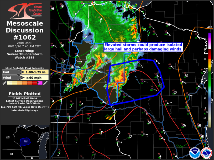
Mesoscale Discussion 1062 NWS Storm Prediction Center Norman OK 0618 AM CDT Wed Jun 10 2026 Areas affected...Western/central Wisconsin Concerning...Severe Thunderstorm Watch 299... Valid 101118Z - 101245Z The severe weather threat for Severe Thunderstorm Watch 299 continues. SUMMARY...An isolated large hail and damaging wind threat will accompany a small cluster of storms moving into central Wisconsin this morning. DISCUSSION...Warm advection over the outflow from earlier morning convection has promoted a few stronger/deeper thunderstorms within the northern Coulee region. This activity is on the fringe of the steeper mid-level lapse rates and effective shear (perhaps around 25-30 kt). It is not clear how far east this complex of storms will progress as buoyancy and shear decrease with eastward extent and the low-level jet will weaken. The current thinking is that isolated large hail and perhaps strong/damaging winds are possible over the next 1-2 hours. An additional watch is not currently expected this morning. ..Wendt.. 06/10/2026 ...Please see www.spc.noaa.gov for graphic product... ATTN...WFO...GRB...ARX...MPX... LAT...LON 44429155 45059143 45229022 45188981 44898957 44478942 44268970 44099066 43989142 44429155 MOST PROBABLE PEAK WIND GUST...UP TO 60 MPH MOST PROBABLE PEAK HAIL SIZE...1.00-1.75 IN |
|
|
Top/All Mesoscale Discussions/Forecast Products/Home |
|
Source link