| Mesoscale Discussion 1004 | |
| < Previous MD | |

|
|
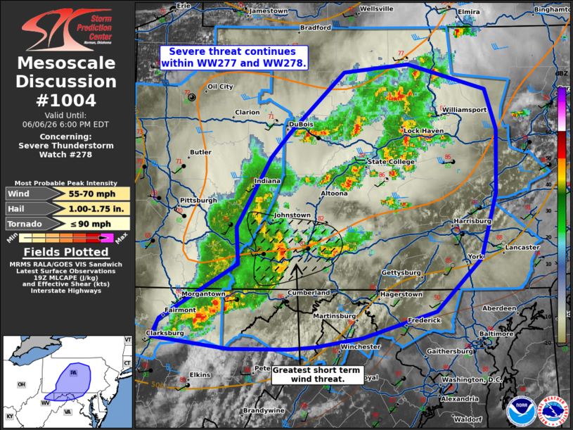
Mesoscale Discussion 1004 NWS Storm Prediction Center Norman OK 0257 PM CDT Sat Jun 06 2026 Areas affected...central Pennsylvania into northern Maryland/West Virginia Concerning...Severe Thunderstorm Watch 278... Valid 061957Z - 062200Z The severe weather threat for Severe Thunderstorm Watch 278 continues. SUMMARY...Severe threat continues within WW277 and WW278. DISCUSSION...Several clusters of thunderstorm activity continue across much of PA into northern MD/WV this afternoon. The strongest cluster to the south has produced winds around 60-75 mph over the last hour. Radar presentation continues to show 50-60 kt winds in the lowest 3-5 kft. Given continued warming/destabilization to the east, this will likely be where the greatest short term risk for severe winds 60-70+ mph. Additionally, strong to severe gusts will continue with the clusters to the north and east. ..Thornton.. 06/06/2026 ...Please see www.spc.noaa.gov for graphic product... ATTN...WFO...PHI...CTP...LWX...PBZ...RLX... LAT...LON 39227844 39197873 39207941 39298027 39458019 39947931 40267932 40877893 41097872 41607810 41687738 41467649 41107636 40557638 39987654 39537706 39297789 39227844 MOST PROBABLE PEAK TORNADO INTENSITY...UP TO 90 MPH MOST PROBABLE PEAK WIND GUST...55-70 MPH MOST PROBABLE PEAK HAIL SIZE...1.00-1.75 IN |
|
|
Top/All Mesoscale Discussions/Forecast Products/Home |
|
Source link