| Mesoscale Discussion 1002 | |
| < Previous MD | |

|
|
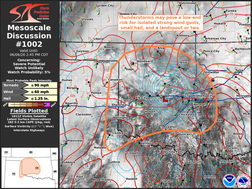
   Mesoscale Discussion 1002
   NWS Storm Prediction Center Norman OK
   0117 PM CDT Sat Jun 06 2026

   Areas affected...portions of the eastern Texas Panhandle into
   western and central Oklahoma

   Concerning...Severe potential...Watch unlikely

   Valid 061817Z - 061945Z

   Probability of Watch Issuance...5 percent

   SUMMARY...Widely scattered thunderstorms may pose a low-end risk for
   isolated strong to occasionally damaging wind gusts, small hail, and
   a landspout or two.

   DISCUSSION...Latest surface analysis depicts a surface low west of
   the Oklahoma City Metro, downstream of a mid-level closed low/MCV.
   More prevalent cloud cover is tempering diurnal
   heating/destabilization across portions of this area compared to
   areas farther south, but guidance still suggests 1000 to locally
   1500 J/kg MLCAPE will be present by peak heating this afternoon.
   This is expected to support widely scattered thunderstorm
   development this afternoon from the eastern Texas Panhandle into
   western/central Oklahoma. Deep-layer flow is also weaker across this
   region, with effective shear analyzed at 20-25 kts or less. While
   this should largely inhibit updraft/storm organization, high PWAT
   contents (1.6 inches or greater per latest objective analysis) may
   promote occasional strong wind gusts with water-loaded downbursts
   and perhaps an instance or two of damaging wind gusts. Enhanced
   surface vertical vorticity in the vicinity of the aforementioned
   surface low and increasing 0-3 km CAPE through the afternoon will
   also foster a risk for a landspout or two. Lastly, small to perhaps
   marginally severe hail may accompany the most robust updrafts. Watch
   issuance is not expected given the limited magnitude/coverage of the
   severe threat.

   ..Chalmers/Thompson.. 06/06/2026

   ...Please see www.spc.noaa.gov for graphic product...

   ATTN...WFO...OUN...LUB...AMA...

   LAT...LON   34229963 34069994 33980009 34010031 34180042 34520043
               35110039 35870033 36260025 36539997 36719978 36909903
               36899821 36689764 36229704 35639668 35149664 34799670
               34579696 34479724 34549758 34589798 34559849 34439901
               34229963

   MOST PROBABLE PEAK TORNADO INTENSITY...UP TO 90 MPH
   MOST PROBABLE PEAK WIND GUST...UP TO 60 MPH
   MOST PROBABLE PEAK HAIL SIZE...UP TO 1.25 IN
|
|
|
Top/All Mesoscale Discussions/Forecast Products/Home |
|
Source link