| Mesoscale Discussion 968 | |
| < Previous MD Next MD > | |

|
|
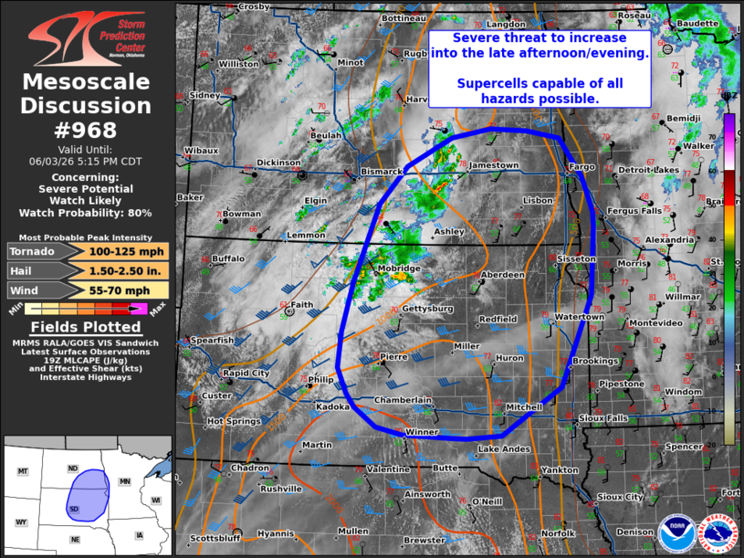
   Mesoscale Discussion 0968
   NWS Storm Prediction Center Norman OK
   0243 PM CDT Wed Jun 03 2026

   Areas affected...eastern Dakotas into far western Minnesota

   Concerning...Severe potential...Watch likely

   Valid 031943Z - 032215Z

   Probability of Watch Issuance...80 percent

   SUMMARY...Severe threat to increase into the late afternoon/evening.
   Supercells capable of all hazards will be possible.

   DISCUSSION...Remnant outflow/thunderstorm activity continues to move
   northward across central South Dakota this afternoon, with
   occasional stronger cores producing hail up to 1 inch. Widespread
   cloud cover accompanies the surface low/outflow boundary into
   western/central South Dakota. Less cloud cover is in place across
   eastern South Dakota where temperatures are slowly warming into the
   mid 70s to 80s and higher theta-e air is nudging northward.

   Exact timing of the more appreciable severe threat remains somewhat
   uncertain given cloud cover and slow heating/destabilization.
   Guidance suggests that as the outflow lifts northward this evening,
   convective initiation will occur along and south of the outflow and
   along the cold front to the west. Temperatures warming into the 80s
   amid dew points in the low to mid 60s should support MLCAPE around
   1500-2000 J/kg. Forecast soundings depict elongated hodographs which
   would support supercells capable of large to very large hail and
   tornadoes. A watch will be needed to cover this potential by the
   late afternoon/early evening.

   ..Thornton/Mosier.. 06/03/2026

   ...Please see www.spc.noaa.gov for graphic product...

   ATTN...WFO...MPX...FGF...FSD...ABR...BIS...UNR...

   LAT...LON   47339693 46829650 46369631 46169631 45269637 44059695
               43409807 43369872 43379899 43419988 43510038 43770077
               43950093 44290110 44780104 45430083 46460036 46979984
               47349899 47479826 47449756 47339693

   MOST PROBABLE PEAK TORNADO INTENSITY...100-125 MPH
   MOST PROBABLE PEAK WIND GUST...55-70 MPH
   MOST PROBABLE PEAK HAIL SIZE...1.50-2.50 IN
|
|
|
Top/All Mesoscale Discussions/Forecast Products/Home |
|
Source link