| Mesoscale Discussion 938 | |
| < Previous MD Next MD > | |

|
|
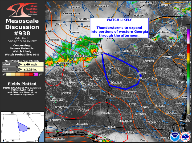
   Mesoscale Discussion 0938
   NWS Storm Prediction Center Norman OK
   0325 PM CDT Mon Jun 01 2026

   Areas affected...west-central Georgia

   Concerning...Severe potential...Watch likely

   Valid 012025Z - 012130Z

   Probability of Watch Issuance...95 percent

   SUMMARY...Thunderstorm activity to expand into west-central Georgia
   this afternoon with potential for damaging winds.

   DISCUSSION...A line of thunderstorms continues to move southeast
   across central Alabama this afternoon. Guidance from the 18z HRRR
   suggests storms will expand into western Georgia over the next
   couple of hours. MLCAPE is slowly increasing across the area, with
   around 1500-2500 J/kg from west-central to southern Georgia amid
   steep low-level lapse rates. This will support potential for strong
   to severe winds through the afternoon/evening. A watch will be
   needed to cover this potential soon.

   ..Thornton.. 06/01/2026

   ...Please see www.spc.noaa.gov for graphic product...

   ATTN...WFO...FFC...BMX...

   LAT...LON   33758537 33608489 33368428 33098372 32808349 32458366
               32258421 32398499 32748515 33298531 33508534 33758537

   MOST PROBABLE PEAK WIND GUST...UP TO 60 MPH
   MOST PROBABLE PEAK HAIL SIZE...UP TO 1.25 IN
|
|
|
Top/All Mesoscale Discussions/Forecast Products/Home |
|
Source link