| Mesoscale Discussion 927 | |
| < Previous MD | |

|
|
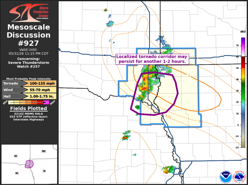
Mesoscale Discussion 0927 NWS Storm Prediction Center Norman OK 0915 PM CDT Sun May 31 2026 Areas affected...Far southeast South Dakota into adjacent portions of Nebraska and Iowa Concerning...Severe Thunderstorm Watch 257... Valid 010215Z - 010415Z The severe weather threat for Severe Thunderstorm Watch 257 continues. SUMMARY...A localized corridor of higher tornado potential may persist for the next couple of hours across far southeast South Dakota into adjacent portions of Iowa and Nebraska. DISCUSSION...Additional tornadic supercells have emerged immediately west of the Sioux Falls, SD and the I-29 corridor based on radar imagery from KFSD. Near-storm 0-1 km SRH sampled by the local VWP has recently increased to around 200 m2/s2 immediately ahead of the approaching storms. Consequently, the near-storm environment is more favorable for tornadoes than previously anticipated, though storm interactions appear to be modulating the duration of the tornado threat to some degree. Additional supercell development is noted on the southern flank of the emerging cluster, and is already showing signs of an organizing low-level mesocyclone. It appears likely that some tornado threat will likely continue for the next 1-2 hours - most likely on the southern flank of the cluster as it migrates east/southeast into far northeast NE/northwest IA. Based on the near-storm environment and observed velocity signatures, a strong tornado appears possible. ..Moore.. 06/01/2026 ...Please see www.spc.noaa.gov for graphic product... ATTN...WFO...FSD...OAX... LAT...LON 42589728 43109709 43329697 43359662 43289611 43139602 42919595 42689607 42519629 42459661 42489704 42589728 MOST PROBABLE PEAK TORNADO INTENSITY...100-125 MPH MOST PROBABLE PEAK WIND GUST...55-70 MPH MOST PROBABLE PEAK HAIL SIZE...1.00-1.75 IN |
|
|
Top/All Mesoscale Discussions/Forecast Products/Home |
|
Source link