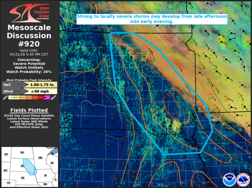
MD 0920 CONCERNING SEVERE POTENTIAL…WATCH UNLIKELY FOR EASTERN SD AND ADJACENT PARTS OF NORTHEAST NE…NORTHWEST IA…AND SOUTHWEST MN
Mesoscale Discussion 0920
NWS Storm Prediction Center Norman OK
0320 PM CDT Sun May 31 2026

Areas affected...Eastern SD and adjacent parts of northeast
NE...northwest IA...and southwest MN

Concerning...Severe potential...Watch unlikely

Valid 312020Z - 312245Z

Probability of Watch Issuance...20 percent

SUMMARY...Strong to locally severe storms will be possible from late
afternoon into early evening.

DISCUSSION...Cumulus has been gradually deepening this afternoon
near a surface confluence zone across eastern SD, with recent
attempts at convective initiation near Yankton. Diurnal heating to
the south and west of substantial mid/upper-level cloudiness has
allowed for moderate destabilization, with MLCAPE increasing above
1500 J/kg where stronger heating has occurred. This area of stronger
heating is occurring underneath substantial midlevel drying in the
wake of a midlevel shortwave passage, and potential for updrafts to
mature within the midlevel dry slot is uncertain through the
afternoon. Eventually, ascent associated with an upstream midlevel
shortwave trough over western SD may allow for isolated to scattered
storm develop across parts of eastern SD and vicinity from late
afternoon into early evening.

18Z OAX and ABR soundings depict modest deep-layer flow and
effective shear of around 30 kt, marginally supportive of organized
convection where stronger destabilization has occurred. A few strong
multicells and perhaps a transient supercell could evolve with time,
though backing of upper-level flow could lead to messy/complex storm
modes. Isolated hail and damaging gusts could accompany the
strongest storms, though magnitude and coverage of the threat may
tend to remain limited.

..Dean/Thompson.. 05/31/2026

...Please see www.spc.noaa.gov for graphic product...

ATTN...WFO...FSD...OAX...ABR...BIS...LBF...

LAT...LON   42239779 43549922 44269981 44919995 45840012 45920006
            45959910 45639838 45399795 44649713 43729601 42959578
            42299630 42239779

MOST PROBABLE PEAK WIND GUST...UP TO 60 MPH
MOST PROBABLE PEAK HAIL SIZE...1.00-1.75 IN
Source link