| Mesoscale Discussion 911 | |
| < Previous MD | |

|
|
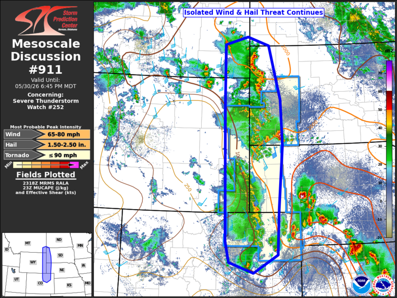
Mesoscale Discussion 0911 NWS Storm Prediction Center Norman OK 0620 PM CDT Sat May 30 2026 Areas affected...parts of western Nebraska and South Dakota...northeast Colorado...and extreme eastern Wyoming Concerning...Severe Thunderstorm Watch 252... Valid 302320Z - 310045Z The severe weather threat for Severe Thunderstorm Watch 252 continues. SUMMARY...Thunderstorms will continue to develop this evening across Severe Thunderstorm Watch #252. Isolated large hail and strong winds will remain possible across the watch. DISCUSSION...Thunderstorms continue to develop and grow upscale into north-south linear clusters this afternoon/evening to the northeast of a negatively tilted mid-level trough moving across north-central Colorado into eastern Wyoming. The overall environment remains favorable for strong to severe thunderstorms, with MUCAPE in the 1000-2000 J/kg range, with deep-layer shear on the order of 30 knots. However, deep-layer shear is mostly parallel to the initiating boundaries, which will favor seeding of downstream updrafts, acting as an overall check on thunderstorm intensity. Thus, despite overall an environment that would support a sustained hail and wind threat this evening, the most likely scenario is for any severe hail or wind to occur on an isolated basis with the strongest of updraft cores as the overall complex moves east into the central/northern Plains. The activity should weaken later this evening with the loss of diurnal heating. ..Marsh.. 05/30/2026 ...Please see www.spc.noaa.gov for graphic product... ATTN...WFO...BIS...LBF...UNR...BOU...CYS...BYZ... LAT...LON 40130499 44210505 45970504 46210410 45950324 44340278 42980271 41080287 39730293 39180389 39500486 40130499 MOST PROBABLE PEAK TORNADO INTENSITY...UP TO 90 MPH MOST PROBABLE PEAK WIND GUST...65-80 MPH MOST PROBABLE PEAK HAIL SIZE...1.50-2.50 IN |
|
|
Top/All Mesoscale Discussions/Forecast Products/Home |
|
Source link