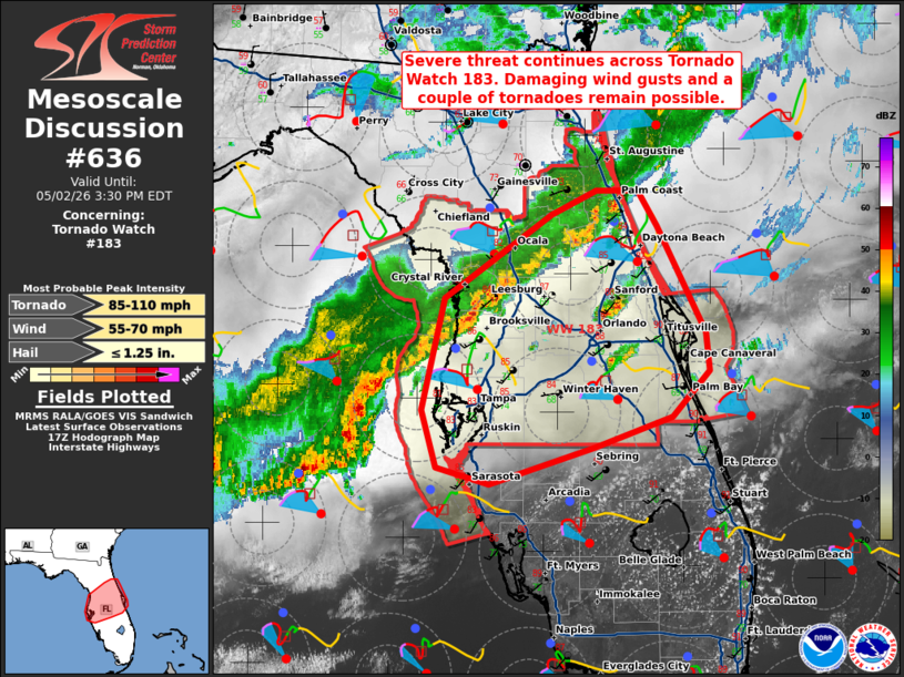
MD 0636 CONCERNING TORNADO WATCH 183… FOR PORTIONS OF NORTH AND CENTRAL FLORIDA
Mesoscale Discussion 0636
NWS Storm Prediction Center Norman OK
1257 PM CDT Sat May 02 2026

Areas affected...portions of North and Central Florida

Concerning...Tornado Watch 183...

Valid 021757Z - 021930Z

The severe weather threat for Tornado Watch 183 continues.

SUMMARY...The potential for severe/damaging wind gusts and a couple
of tornadoes continues across Tornado Watch 183.

DISCUSSION...A band of thunderstorms along a surface cold front
extending from near the Ocala National Forest southwestward into the
eastern Gulf has produced a few measured wind gusts in the 45-55 mph
range over the past 1-2 hours. Continued insolation amid surface
dewpoints near 70 F is yielding 1000-2000 J/kg MLCAPE across much of
the Florida Peninsula ahead of this line. Strong effective bulk
shear of 40-50+ kts (per latest mesoanalysis) will continue to
promote storm organization, with shear vectors oriented parallel to
the cold front favoring a linear storm mode. The presence of some
mid-level dry air (evident in recent TPA/SRQ ACARS profiles) as well
as increasingly steep low-level lapse rates will continue to support
the potential for strong to severe wind gusts. Despite largely
veered surface winds, a couple of tornadoes also remain possible
given modestly-favorable low-level shear profiles. The greatest
severe potential will likely exist with any line segments that
attain a more favorable north-south orientation given generally
westerly shear vectors. Small to marginally severe hail may also
occur with any stronger updrafts, especially any persistent,
more-discrete updrafts forming ahead of the main line.

..Chalmers.. 05/02/2026

...Please see www.spc.noaa.gov for graphic product...

ATTN...WFO...MLB...TBW...JAX...

LAT...LON   28788275 29458181 29648141 29648104 29358087 28528044
            28228041 27858074 27628142 27338236 27458282 27918296
            28788275

MOST PROBABLE PEAK TORNADO INTENSITY...85-110 MPH
MOST PROBABLE PEAK WIND GUST...55-70 MPH
MOST PROBABLE PEAK HAIL SIZE...UP TO 1.25 IN
Source link