| Mesoscale Discussion 629 | |
| < Previous MD | |

|
|
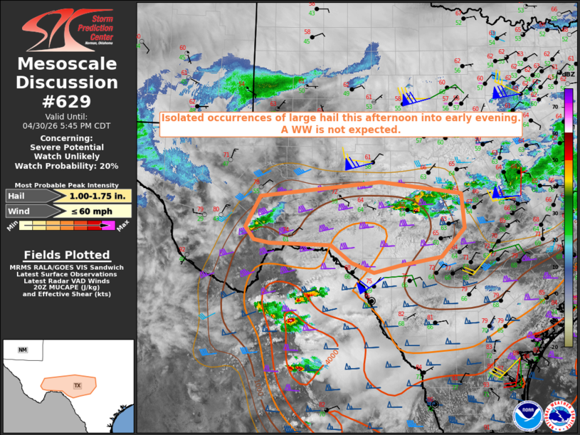
   Mesoscale Discussion 0629
   NWS Storm Prediction Center Norman OK
   0347 PM CDT Thu Apr 30 2026

   Areas affected...Texas Big Bend into Concho Valley and Edwards
   Plateau

   Concerning...Severe potential...Watch unlikely

   Valid 302047Z - 302245Z

   Probability of Watch Issuance...20 percent

   SUMMARY...Isolated occurrences of large hail are possible this
   afternoon into early evening. A WW is not currently expected.

   DISCUSSION...A small area of elevated thunderstorms is ongoing as of
   2040z in the vicinity of Junction, TX, with potentially more
   surface-based storm development occurring farther to the west along
   the higher terrain in the vicinity of Marathon, TX. Latest objective
   analysis suggests these storms are occurring in a modestly unstable
   air mass, characterized by MUCAPE of 1000-1500 J/kg. Ambient wind
   shear through a deep layer remains strong (e.g., effective bulk
   shear magnitudes of 55-65 kt), so the potential exists for supercell
   structures capable of large hail.

   The current expectation is that any hail threat will remain isolated
   and somewhat marginal in intensity into early evening. As such a
   Severe Thunderstorm Watch isn't expected at this time.

   Storm coverage and intensity may tend to increase later this evening
   into tonight with the arrival of stronger forcing for ascent
   attendant to a low-latitude short-wave trough moving through
   northwest Mexico. Comparably greater potential for a watch will
   exist at that time.

   ..Mead/Smith.. 04/30/2026

   ...Please see www.spc.noaa.gov for graphic product...

   ATTN...WFO...EWX...SJT...MAF...

   LAT...LON   30170316 30740284 31010033 30789863 30169856 29639905
               29489991 29350047 29540093 29850136 29890264 29950298
               30170316

   MOST PROBABLE PEAK WIND GUST...UP TO 60 MPH
   MOST PROBABLE PEAK HAIL SIZE...1.00-1.75 IN
|
|
|
Top/All Mesoscale Discussions/Forecast Products/Home |
|
Source link