| Mesoscale Discussion 621 | |
| < Previous MD | |

|
|
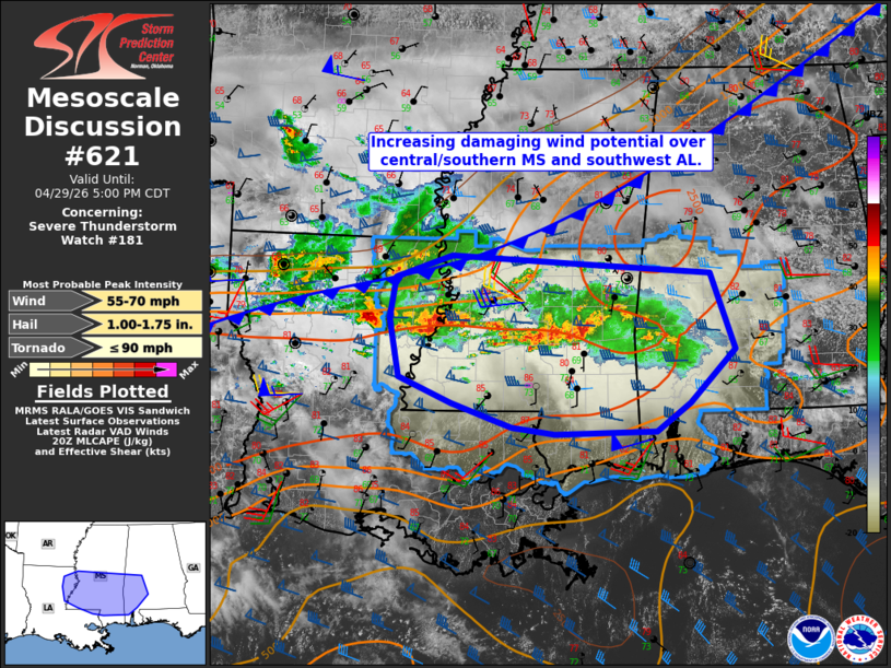
Mesoscale Discussion 0621 NWS Storm Prediction Center Norman OK 0302 PM CDT Wed Apr 29 2026 Areas affected...northeast Louisiana...central and southern Mississippi...and southwest Alabama Concerning...Severe Thunderstorm Watch 181... Valid 292002Z - 292200Z The severe weather threat for Severe Thunderstorm Watch 181 continues. SUMMARY...The potential for more widespread wind damage is expected to increase across portions of central and southern Mississippi into southwest Alabama over the next 2-3 hours. DISCUSSION...A west-to-east-oriented band of strong to severe storms is ongoing just south of the I-20 corridor in MS and northeast LA as of 20z. Occurrences of hail to 1" and thunderstorm wind damage have been reported in the Jackson, MS vicinity within the past hour. Additional elevated storms ongoing to the west of the watch area across northern LA are expected to merge with the predominant band of storms over the next hour, which should enhance overall cold pool strength. That process may lead to an accelerated southeastward motion of the convective band from central into southern MS and southwest AL with an attendant risk for more widespread damaging winds. Isolated occurrences of large hail will remain possible, especially on the western flank of the convective system where mid-level lapse rates are steeper. ..Mead.. 04/29/2026 ...Please see www.spc.noaa.gov for graphic product... ATTN...WFO...BMX...MOB...JAN...LIX... LAT...LON 32069181 32549174 32809096 32718925 32598742 31718710 31098772 30768818 30738956 30819015 31099097 31389169 32069181 MOST PROBABLE PEAK TORNADO INTENSITY...UP TO 90 MPH MOST PROBABLE PEAK WIND GUST...55-70 MPH MOST PROBABLE PEAK HAIL SIZE...1.00-1.75 IN |
|
|
Top/All Mesoscale Discussions/Forecast Products/Home |
|
Source link