| Mesoscale Discussion 614 | |
| < Previous MD | |

|
|
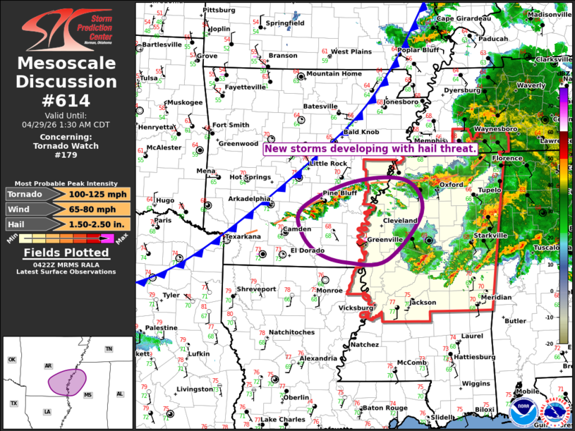
Mesoscale Discussion 0614 NWS Storm Prediction Center Norman OK 1125 PM CDT Tue Apr 28 2026 Areas affected...Eastern Arkansas and Northwest Mississippi Concerning...Tornado Watch 179... Valid 290425Z - 290630Z The severe weather threat for Tornado Watch 179 continues. SUMMARY...New thunderstorm development over southeast Arkansas will pose a severe hail threat. DISCUSSION...Thunderstorms have developed over the last 45 min over southeast AR, along a pre-frontal boundary. These storms are in a very moist and moderately unstable air mass with MLCAPE value around 1000 J/kg. Storms have intensified rapidly with MESH values suggesting severe hail is already occurring. VADs at LZK/NQA and model guidance show substantial veering of low-level winds has occurred in this area, suggesting hail is the main concern as these storms track eastward into WW179 during the next couple of hours. Nevertheless, sufficient low-level shear remains for at least the risk of an isolated tornado. ..Hart.. 04/29/2026 ...Please see www.spc.noaa.gov for graphic product... ATTN...WFO...MEG...JAN...LZK... LAT...LON 34059240 34519134 34549019 33968986 33129060 33099144 33259205 33609241 34059240 MOST PROBABLE PEAK TORNADO INTENSITY...100-125 MPH MOST PROBABLE PEAK WIND GUST...65-80 MPH MOST PROBABLE PEAK HAIL SIZE...1.50-2.50 IN |
|
|
Top/All Mesoscale Discussions/Forecast Products/Home |
|
Source link