| Mesoscale Discussion 613 | |
| < Previous MD | |

|
|
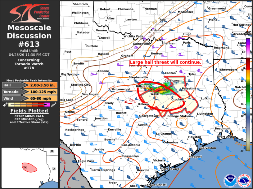
Mesoscale Discussion 0613 NWS Storm Prediction Center Norman OK 0928 PM CDT Tue Apr 28 2026 Areas affected...North Central TX Concerning...Tornado Watch 178... Valid 290228Z - 290430Z The severe weather threat for Tornado Watch 178 continues. SUMMARY...Supercells capable of very large hail will continue to track southeastward. DISCUSSION...Two intense supercells continue to affect parts of north-central TX, over Hill/Bosque/Limestone counties. This cluster of storms has a long history of significant hail damage during the past few hours. CAPE values remain very high, with steep lapse rates and strong deep layer shear indicated on the 00z FWD sounding. However, cap strength is increasing as the boundary layer slowly cools. This is likely to lead to some weakening over the next couple of hours. Nevertheless, some severe risk will likely persist until at least midnight. ..Hart.. 04/29/2026 ...Please see www.spc.noaa.gov for graphic product... ATTN...WFO...HGX...FWD... LAT...LON 32079763 31989653 31239549 30949649 31349751 32079763 MOST PROBABLE PEAK TORNADO INTENSITY...100-125 MPH MOST PROBABLE PEAK WIND GUST...65-80 MPH MOST PROBABLE PEAK HAIL SIZE...2.00-3.50 IN |
|
|
Top/All Mesoscale Discussions/Forecast Products/Home |
|
Source link