| Mesoscale Discussion 612 | |
| < Previous MD Next MD > | |
|
|
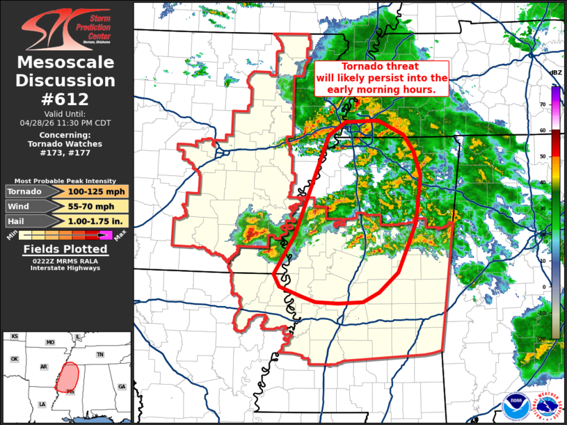
Mesoscale Discussion 0612 NWS Storm Prediction Center Norman OK 0924 PM CDT Tue Apr 28 2026 Areas affected...Eastern Arkansas...northern Mississippi...and far southwest Tennessee Concerning...Tornado Watch 173...177... Valid 290224Z - 290430Z The severe weather threat for Tornado Watch 173, 177 continues. SUMMARY...Severe thunderstorms will continue to migrate across a favorably sheared environment through the early morning hours. The threat for severe winds, hail, and tornadoes will likely persist and necessitate new watch issuance and/or local temporal extensions. DISCUSSION...Regional velocity data continues to show mid-level mesocyclones with a pair of supercells across southeast AR as well as weaker circulations within a mix of convective clusters and weak supercells across far eastern AR, northern MS, and far southwest TN. Latest mesoanalyses trends show overall buoyancy decreasing from east to west due to the onset of nocturnal cooling. However, dewpoints in the mid 60s to low 70s along and near the MS River will likely modulate nocturnal stabilization and maintain sufficient MLCAPE to sustain ongoing surface-based convection. Additionally, regional VWPs and RAP mesoanalysis estimates depict effective SRH on the order of 200-400 m2/s2, which will help maintain some tornado threat. Given these trends, the expectation is that some severe risk will persist into the early morning hours and will require either local extensions in time of ongoing watches and/or new watch issuance within the hour. ..Moore.. 04/29/2026 ...Please see www.spc.noaa.gov for graphic product... ATTN...WFO...MEG...JAN... LAT...LON 32999134 33569098 35029040 35219010 35248953 35038908 34798892 34438880 33758888 33438902 33038919 32738952 32598981 32589023 32609063 32689087 32829124 32999134 MOST PROBABLE PEAK TORNADO INTENSITY...100-125 MPH MOST PROBABLE PEAK WIND GUST...55-70 MPH MOST PROBABLE PEAK HAIL SIZE...1.00-1.75 IN |
|
|
Top/All Mesoscale Discussions/Forecast Products/Home |
|
Source link