| Mesoscale Discussion 611 | |
| < Previous MD | |
|
|
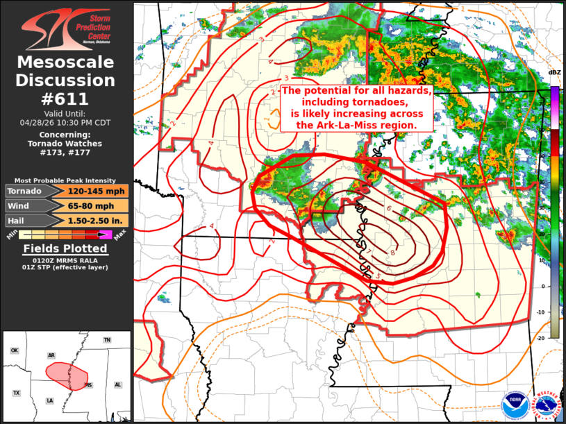
Mesoscale Discussion 0611 NWS Storm Prediction Center Norman OK 0823 PM CDT Tue Apr 28 2026 Areas affected...Southeast Arkansas...western Mississippi...and far northeast Louisiana Concerning...Tornado Watch 173...177... Valid 290123Z - 290330Z The severe weather threat for Tornado Watch 173, 177 continues. SUMMARY...The threat for severe wind, hail, and tornadoes is likely increasing for the ArkLaMiss region as thunderstorms intensify upstream. DISCUSSION...Over the past 30-45 minutes, new convection has developed across southeast AR within a focused zone of low-level warm air advection. Velocity data from KDGX reveals an organized mid-level mesocyclone with one of these cells while lightning counts continue to increase. This activity will continue to spread southeast towards the ArkLaMiss region over the next couple of hours. Regional VWPs are beginning to show the early onset of the nocturnal jet with 0-1 km SRH increasing to 250-300 m2/s2 over the past hour. Although nocturnal cooling has begun, it will likely be modulated due to high dewpoints in the upper 60s to mid 70s. This low-level moisture continues to support MLCAPE values in the 1000-2000 J/kg range immediately downstream of the intensifying convection with STP values remaining between 4-7. Consequently, the severe threat will likely increase over the next hour or so (including the potential for significant tornadoes) as this convection traverses a highly favorable environment. ..Moore.. 04/29/2026 ...Please see www.spc.noaa.gov for graphic product... ATTN...WFO...MEG...JAN...LZK...SHV... LAT...LON 33029226 33199263 33419286 33649291 33869280 34159225 34169174 34059106 33498977 33158975 32838983 32648998 32489029 32399063 32449105 33029226 MOST PROBABLE PEAK TORNADO INTENSITY...120-145 MPH MOST PROBABLE PEAK WIND GUST...65-80 MPH MOST PROBABLE PEAK HAIL SIZE...1.50-2.50 IN |
|
|
Top/All Mesoscale Discussions/Forecast Products/Home |
|
Source link