| Mesoscale Discussion 606 | |
| < Previous MD Next MD > | |
|
|
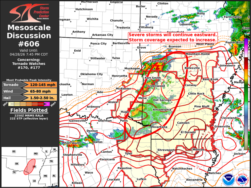
Mesoscale Discussion 0606 NWS Storm Prediction Center Norman OK 0552 PM CDT Tue Apr 28 2026 Areas affected...Much of Arkansas...northwest Louisiana...Northeast Texas...Southeast Oklahoma Concerning...Tornado Watch 170...177... Valid 282252Z - 290045Z The severe weather threat for Tornado Watch 170, 177 continues. SUMMARY...Multiple clusters of thunderstorms will track into western AR this evening, with coverage of other storms increasing toward sunset. DISCUSSION...Three distinct clusters of severe/supercell storms are present this afternoon over OK/AR. One is southeast of FYV, one near FSM, and a third near IDA. These storms will track eastward for several more hours into a very moist and moderately unstable air mass. Forecast soundings and the LZK VAD profile suggest sufficient low-level and deep-layer shear for continued supercell storm structures and a risk of all severe modes. The low-level jet is expected to strengthen this evening around dusk, resulting in increased coverage of storms, and increasing the risk of a few tornadoes. New tornado watch #177 has just been issued for this area until 06z. ..Hart.. 04/28/2026 ...Please see www.spc.noaa.gov for graphic product... ATTN...WFO...LZK...SHV...TSA... LAT...LON 34209505 35129443 35939393 36499289 36279228 34989251 33629335 33059468 33289520 33739527 34209505 MOST PROBABLE PEAK TORNADO INTENSITY...120-145 MPH MOST PROBABLE PEAK WIND GUST...65-80 MPH MOST PROBABLE PEAK HAIL SIZE...1.50-2.50 IN |
|
|
Top/All Mesoscale Discussions/Forecast Products/Home |
|
Source link