| Mesoscale Discussion 425 | |
| < Previous MD | |

|
|
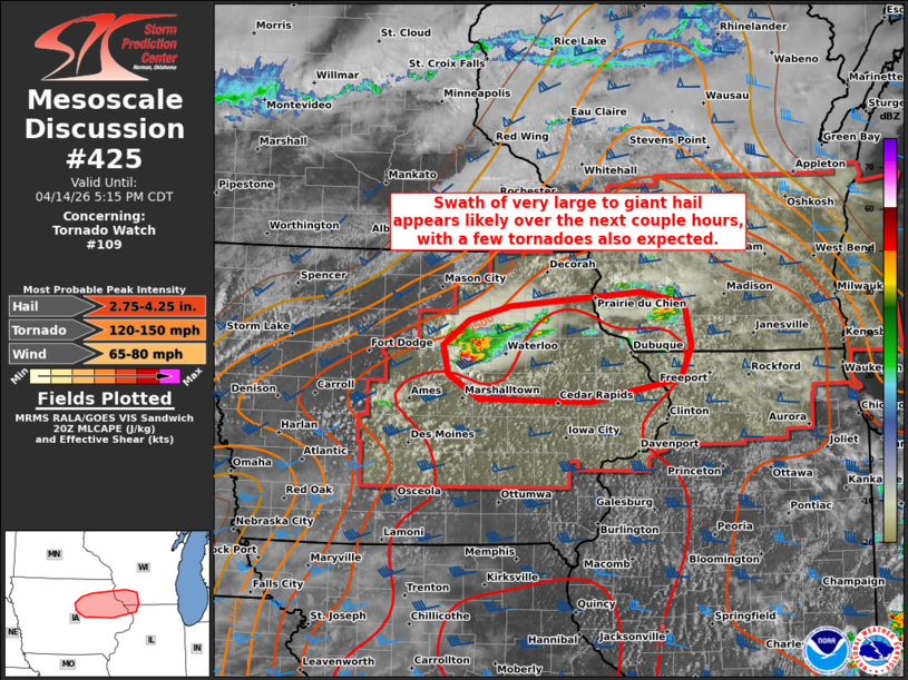
Mesoscale Discussion 0425 NWS Storm Prediction Center Norman OK 0342 PM CDT Tue Apr 14 2026 Areas affected...Parts of northeast/east-central IA...southwest WI...and far northwest IL Concerning...Tornado Watch 109... Valid 142042Z - 142215Z The severe weather threat for Tornado Watch 109 continues. SUMMARY...A swath of very large to giant hail (3+ inches in diameter) appears likely over the next couple hours, with a few tornadoes also expected. The tornado risk will continue to increase through the afternoon into this evening. DISCUSSION...A dominant right-moving supercell has rapidly intensified immediately south of a quasi-stationary surface front extending across central IA, with additional storm splits evolving along its northern flank. This storm has recent reports of a tornado and 1.75 inch hail. Ahead of this storm, a strongly unstable air mass (around 4500 J/kg SBCAPE per modified 18Z DVN special sounding) and 50 kt of effective shear will favor continued intensification of this storm and additional storms forming along its flanks and near the surface boundary over the next few hours. Given a long/mostly straight hodograph (per VWP data), splitting supercells with dominant right-movers will pose a risk of very large to giant hail (some 3+ inches in diameter) and a few tornadoes. With time, low-level hodographs will increase in size/clockwise curvature as a low-level jet strengthens through the afternoon into the evening. This will support an increasing risk of strong to intense tornadoes with any established semi-discrete supercells. ..Weinman.. 04/14/2026 ...Please see www.spc.noaa.gov for graphic product... ATTN...WFO...MKX...DVN...ARX...DMX... LAT...LON 42569317 42829282 42969226 43109053 42998994 42568984 42248999 42009121 42049267 42289310 42569317 MOST PROBABLE PEAK TORNADO INTENSITY...120-150 MPH MOST PROBABLE PEAK WIND GUST...65-80 MPH MOST PROBABLE PEAK HAIL SIZE...2.75-4.25 IN |
|
|
Top/All Mesoscale Discussions/Forecast Products/Home |
|
Source link