| Mesoscale Discussion 424 | |
| < Previous MD | |
|
|
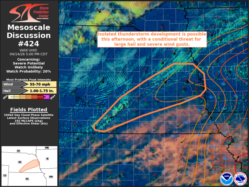
   Mesoscale Discussion 0424
   NWS Storm Prediction Center Norman OK
   0253 PM CDT Tue Apr 14 2026

   Areas affected...portions of south-central and eastern Nebraska into
   extreme western Iowa

   Concerning...Severe potential...Watch unlikely

   Valid 141953Z - 142200Z

   Probability of Watch Issuance...20 percent

   SUMMARY...Isolated thunderstorm development is possible this
   afternoon across portions of south-central Nebraska along a
   stationary boundary, with a conditional threat for large hail and
   severe wind gusts with any storm that can develop.

   DISCUSSION...Latest surface analysis depicts a stationary boundary
   extending northeast to southwest across eastern/south-central
   Nebraska, with a surface low analyzed near OMA. A corridor of higher
   surface dewpoints (low-to-mid 50s F) located along the cool side of
   this boundary is contributing to 250-750 J/kg MLCAPE, with forecast
   soundings and mesoanalysis depicting eroding MLCIN as surface
   temperatures continue to warm. Despite only weak available buoyancy,
   strong southwesterly flow aloft (40+ kt at 3 km AGL per the UEX VWP)
   atop northeasterly surface flow on the cool side of the surface
   boundary is supporting strong effective bulk shear of 50-60 kts.
   Elongated hodographs and steep mid-level lapse rates (per the 18z
   OAX observed sounding) will support a conditional threat for
   isolated large hail with any storm that is able to develop, with
   drier boundary layer profiles immediately south of the surface
   boundary (DCAPE of 800-1000+ J/kg) also supporting some potential
   for strong to occasionally severe wind gusts. This conditional
   severe risk will gradually decrease with time this evening owing to
   low-level nocturnal cooling/stabilization. Given the expectation for
   storm coverage and threat magnitude to remain limited should a storm
   even develop, watch issuance appears unlikely at this time.

   ..Chalmers/Gleason.. 04/14/2026

   ...Please see www.spc.noaa.gov for graphic product...

   ATTN...WFO...OAX...GID...

   LAT...LON   40829690 40519813 40259897 40059957 40099990 40219996
               40379976 40609948 40999900 41529800 41969701 41949630
               41669589 41239583 41079603 40859677 40829690

   MOST PROBABLE PEAK WIND GUST...55-70 MPH
   MOST PROBABLE PEAK HAIL SIZE...1.00-1.75 IN
|
|
|
Top/All Mesoscale Discussions/Forecast Products/Home |
|
Source link