| Mesoscale Discussion 415 | |
| < Previous MD | |
|
|
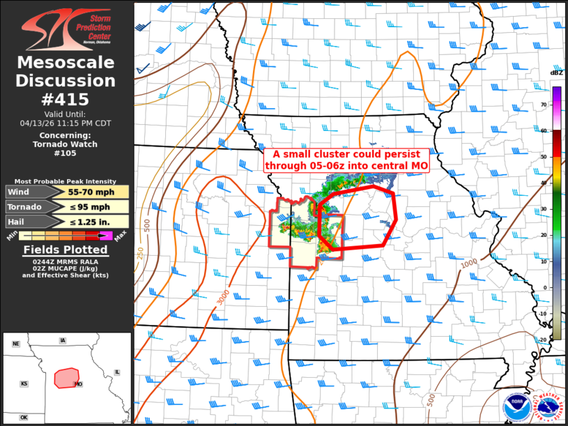
Mesoscale Discussion 0415 NWS Storm Prediction Center Norman OK 0946 PM CDT Mon Apr 13 2026 Areas affected...Central Missouri Concerning...Tornado Watch 105... Valid 140246Z - 140415Z The severe weather threat for Tornado Watch 105 continues. SUMMARY...Occasional wind damage and large hail threat may persist until 05-06z across central Missouri, but the tornado threat is slowly diminishing and a new downstream watch appears unlikely. DISCUSSION...The earlier supercells have undergone cell interactions and modest upscale growth into a cluster with a more expansive cold pool/outflow. A discrete supercell persists to the south in Henry Co. MO, though this storm should be slowly absorbed into the southeast flank of the cluster. Thus, the more probable outcome will be for gradual mergers and development atop the cold pool to allow a storm cluster to persist for another few hours while spreading eastward into central MO. Occasional damaging winds of 60-70 mph and large hail around 1 inch in diameter will be the primary threats, though an isolated/brief tornado will still be possible with embedded circulations along the leading edge of the cold pool, and as the remnant supercell interacts with the cold pool. ..Thompson.. 04/14/2026 ...Please see www.spc.noaa.gov for graphic product... ATTN...WFO...LSX...SGF...EAX... LAT...LON 38429263 38359370 38579399 39099398 39279369 39419284 39299241 38859235 38429263 MOST PROBABLE PEAK TORNADO INTENSITY...UP TO 95 MPH MOST PROBABLE PEAK WIND GUST...55-70 MPH MOST PROBABLE PEAK HAIL SIZE...UP TO 1.25 IN |
|
|
Top/All Mesoscale Discussions/Forecast Products/Home |
|
Source link