| Mesoscale Discussion 408 | |
| < Previous MD Next MD > | |
|
|
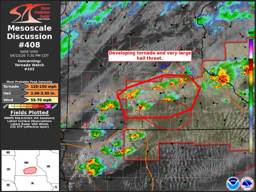
Mesoscale Discussion 0408 NWS Storm Prediction Center Norman OK 0602 PM CDT Mon Apr 13 2026 Areas affected...South-central Minnesota Concerning...Tornado Watch 103... Valid 132302Z - 140030Z The severe weather threat for Tornado Watch 103 continues. SUMMARY...With several discrete storms near the warm front, areas of south-central Minnesota will see an increase in tornado and very-large hail potential this evening. DISCUSSION...Storms have maintained a discrete mode in southern Minnesota late this afternoon. This environment has steeper mid-level lapse rates than farther east and is more closely tied to a subtle shortwave trough in water vapor imagery. Given the expected increase in low-level shear this evening, this area will become more favorable for tornadoes and very-large hail over the next 2-3 hours so long as a discrete storm mode can be maintained. Current VAD observations from KFSD and KARX already show large low-level hodographs that should improve over time. ..Wendt.. 04/13/2026 ...Please see www.spc.noaa.gov for graphic product... ATTN...WFO...ARX...MPX...FSD... LAT...LON 43729487 43959497 44179508 44329482 44589379 44559315 44329283 43899307 43739370 43729487 MOST PROBABLE PEAK TORNADO INTENSITY...120-150 MPH MOST PROBABLE PEAK WIND GUST...55-70 MPH MOST PROBABLE PEAK HAIL SIZE...2.00-3.50 IN |
|
|
Top/All Mesoscale Discussions/Forecast Products/Home |
|
Source link