| Mesoscale Discussion 404 | |
| < Previous MD | |
|
|
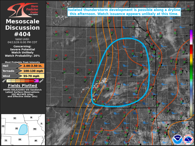
   Mesoscale Discussion 0404
   NWS Storm Prediction Center Norman OK
   0353 PM CDT Mon Apr 13 2026

   Areas affected...portions of eastern Kansas

   Concerning...Severe potential...Watch unlikely

   Valid 132053Z - 132300Z

   Probability of Watch Issuance...20 percent

   SUMMARY...Isolated thunderstorms may develop along a dryline across
   portions of eastern Kansas this afternoon/evening. Any storms that
   do develop will bring a threat for all hazards, with the main threat
   large to very large hail.

   DISCUSSION...Latest visible satellite imagery depicts an area of
   deepening cumulus along a dryline in the vicinity of Wichita,
   Kansas. Ahead of this dryline, surface temperatures in the mid-80s
   and dewpoints in the mid-60s F are contributing to 2000-2500+ J/kg
   MLCAPE within the warm sector. Steep mid-level lapse rates (evident
   on the 18Z LMN special sounding), elongated hodographs (effective
   bulk shear of 30-35+ kts per latest mesoanalysis), and ample
   buoyancy within the hail growth zone will support the potential for
   large to very large hail to 3+ inches in diameter with any storm
   that does develop. The tornado threat remains somewhat more
   conditional on a storm persisting into the evening hours when a
   strengthening nocturnal low-level jet will support increasing
   low-level hodograph curvature and an accompanying increase in the
   tornado threat for any ongoing supercells.

   Watch issuance appears unlikely at this time owing to uncertainty
   regarding the occurrence of convective initiation. Trends will be
   closely monitored and a watch may be needed should initiation appear
   imminent given the conditionally favorable environment.

   ..Chalmers/Hart.. 04/13/2026

   ...Please see www.spc.noaa.gov for graphic product...

   ATTN...WFO...SGF...EAX...TOP...ICT...

   LAT...LON   37629505 37259551 37059638 37129741 37369761 37859758
               38829716 39309681 39569631 39579562 39299513 38709495
               38139494 37629505

   MOST PROBABLE PEAK TORNADO INTENSITY...100-130 MPH
   MOST PROBABLE PEAK WIND GUST...55-70 MPH
   MOST PROBABLE PEAK HAIL SIZE...2.00-3.50 IN
|
|
|
Top/All Mesoscale Discussions/Forecast Products/Home |
|
Source link