| Mesoscale Discussion 393 | |
| < Previous MD | |

|
|
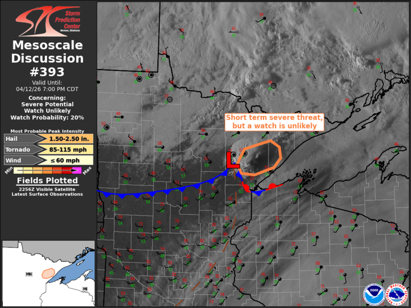
   Mesoscale Discussion 0393
   NWS Storm Prediction Center Norman OK
   0600 PM CDT Sun Apr 12 2026

   Areas affected...Northeast Minnesota

   Concerning...Severe potential...Watch unlikely

   Valid 122300Z - 130000Z

   Probability of Watch Issuance...20 percent

   SUMMARY...A small window for large hail, wind damage and possibly a
   brief tornado, before storms cross over into the cool air and
   weaken.

   DISCUSSION...A small cluster of storms has intensified gradually
   near the surface triple point to the northwest of Duluth.  This
   cluster is located along the northwest edge of the remaining
   warm/moist sector, and immediately west of slow-moving lake breeze.
   There will be a narrow window where the environment will support
   supercells with a low risk of all hazards, but the threat will be
   constrained to large hail once the storm becomes elevated to the
   cool side of the lake breeze.  Given the small area in time and
   space, a watch does not appear necessary.

   ..Thompson/Hart.. 04/12/2026

   ...Please see www.spc.noaa.gov for graphic product...

   ATTN...WFO...DLH...

   LAT...LON   47129163 46979220 46999258 47199271 47319262 47489250
               47579214 47659173 47539146 47319142 47129163

   MOST PROBABLE PEAK TORNADO INTENSITY...85-115 MPH
   MOST PROBABLE PEAK WIND GUST...UP TO 60 MPH
   MOST PROBABLE PEAK HAIL SIZE...1.50-2.50 IN
|
|
|
Top/All Mesoscale Discussions/Forecast Products/Home |
|
Source link