| Mesoscale Discussion 345 | |
| < Previous MD | |

|
|
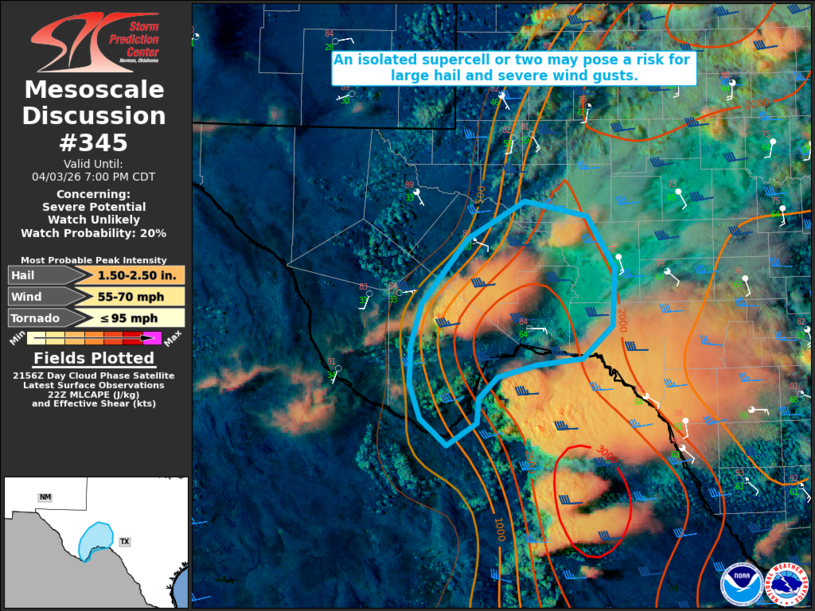
   Mesoscale Discussion 0345
   NWS Storm Prediction Center Norman OK
   0501 PM CDT Fri Apr 03 2026

   Areas affected...portions of the Texas Big Bend into Stockton
   Plateau

   Concerning...Severe potential...Watch unlikely

   Valid 032201Z - 040000Z

   Probability of Watch Issuance...20 percent

   SUMMARY...Isolated supercells forming along a dryline across the
   Texas Big Bend Region into Stockton Plateau will pose a risk of
   large/very large hail and severe wind gusts over the next couple of
   hours.

   DISCUSSION...Thunderstorm development is ongoing south of Fort
   Stockton along a trailing dryline. A moderately unstable environment
   (2000-2500 J/kg MLCAPE) and around 40-50 kts of effective bulk shear
   will favor supercell development capable of large/very large hail
   and severe wind gusts. While mid-level lapse rates remain modest (~7
   C/km), ample buoyancy within the hail growth zone (300-400 J/kg)
   coupled with straight, elongated hodographs will support the
   potential for hail of 2+ inches in diameter with any persistent
   supercell. Given the displacement of better synoptic-scale forcing
   well to the north, storm coverage is expected to remain isolated.
   Thus, watch issuance appears unlikely at this time. A new Severe
   Thunderstorm Watch may need to be considered, however, should
   supercells trend towards more scattered coverage with the potential
   for a longer duration hail threat.

   ..Chalmers/Smith.. 04/03/2026

   ...Please see www.spc.noaa.gov for graphic product...

   ATTN...WFO...EWX...SJT...MAF...

   LAT...LON   29550256 29350277 29100279 28880313 29150343 29480355
               29870354 30270342 30920291 31290225 31130154 30630123
               30060127 29740160 29680213 29550256

   MOST PROBABLE PEAK TORNADO INTENSITY...UP TO 95 MPH
   MOST PROBABLE PEAK WIND GUST...55-70 MPH
   MOST PROBABLE PEAK HAIL SIZE...1.50-2.50 IN
|
|
|
Top/All Mesoscale Discussions/Forecast Products/Home |
|
Source link