| Mesoscale Discussion 342 | |
| < Previous MD Next MD > | |

|
|
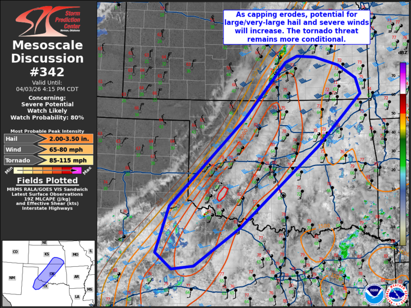
   Mesoscale Discussion 0342
   NWS Storm Prediction Center Norman OK
   0215 PM CDT Fri Apr 03 2026

   Areas affected...Eastern Texas South Plains into central Oklahoma
   and southeast Kansas

   Concerning...Severe potential...Watch likely

   Valid 031915Z - 032115Z

   Probability of Watch Issuance...80 percent

   SUMMARY...A watch is likely this afternoon as initial supercells
   develop along the cold front. Large/very-large hail and severe winds
   will be the main hazards. The tornado threat is conditional on
   maintaining a discrete storm mode into early evening.

   DISCUSSION...The observed 18Z LMN sounding showed a firm cap at
   about 800 mb. Modifying this sounding for nearby current surface
   observations would suggest that this cap is eroding, which is
   supported by visible satellite/regional radars showing a few deeper
   showers/thunderstorms over the last hour. 30-40 kts of effective
   shear will promote initial supercells capable of large/very-large
   hail as well well as severe wind gusts. Given the shear vector
   mostly parallel to the cold front as well as the stronger linear
   forcing, initial activity is expected to congeal somewhat quickly.
   The tornado threat is less clear on account of the initially weak
   low-level shear as well as the transition to a linear mode. However,
   a weak surface low in Northwest Texas into southwest Oklahoma could
   be a zone of greater discrete storm potential. Should those storms
   remain discrete into the evening, there will be an increase in
   low-level shear and, accordingly, a greater tornado risk. This
   scenario is low confidence, though.

   ..Wendt/Hart.. 04/03/2026

   ...Please see www.spc.noaa.gov for graphic product...

   ATTN...WFO...SGF...TSA...ICT...OUN...SJT...LUB...AMA...

   LAT...LON   33290091 34420054 36539837 37919712 38069677 38049623
               37839552 37529501 37139488 35879616 33919847 32999980
               32910044 33290091

   MOST PROBABLE PEAK TORNADO INTENSITY...85-115 MPH
   MOST PROBABLE PEAK WIND GUST...65-80 MPH
   MOST PROBABLE PEAK HAIL SIZE...2.00-3.50 IN
|
|
|
Top/All Mesoscale Discussions/Forecast Products/Home |
|
Source link