| Mesoscale Discussion 340 | |
| < Previous MD | |

|
|
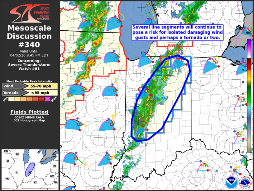
Mesoscale Discussion 0340 NWS Storm Prediction Center Norman OK 0721 PM CDT Thu Apr 02 2026 Areas affected...portions of Indiana Concerning...Severe Thunderstorm Watch 91... Valid 030021Z - 030145Z The severe weather threat for Severe Thunderstorm Watch 91 continues. SUMMARY...Ongoing thunderstorms will continue to pose a risk for isolated damaging wind gusts and perhaps a tornado or two over the next 1-2 hours. DISCUSSION...Several line segments have shown signs of increasing organization/intensity across portions of Indiana, with a stronger mesovortex producing a report of wind damage in Parke County over the last 30-45 minutes. While buoyancy remains weak (250-500 J/kg MLCAPE), strong low-level flow and clockwise-curved hodographs (45-50 kts at 1 km AGL and ~200 m2/s2 0-500 m SRH, respectively, per the IND VWP) will continue to support the potential for line segments and embedded mesovortices capable of isolated damaging winds gusts and perhaps a tornado or two across Severe Thunderstorm Watch 90. Increasing low-level stability owing to nocturnal cooling is then expected to mitigate the severe risk with time this evening. ..Chalmers.. 04/03/2026 ...Please see www.spc.noaa.gov for graphic product... ATTN...WFO...IWX...IND... LAT...LON 40378705 40818674 41258632 41668588 41798534 41618491 41288483 40658519 39838576 39478601 39118658 39058705 39228726 39728725 40378705 MOST PROBABLE PEAK TORNADO INTENSITY...UP TO 95 MPH MOST PROBABLE PEAK WIND GUST...55-70 MPH |
|
|
Top/All Mesoscale Discussions/Forecast Products/Home |
|
Source link