| Mesoscale Discussion 338 | |
| < Previous MD | |

|
|
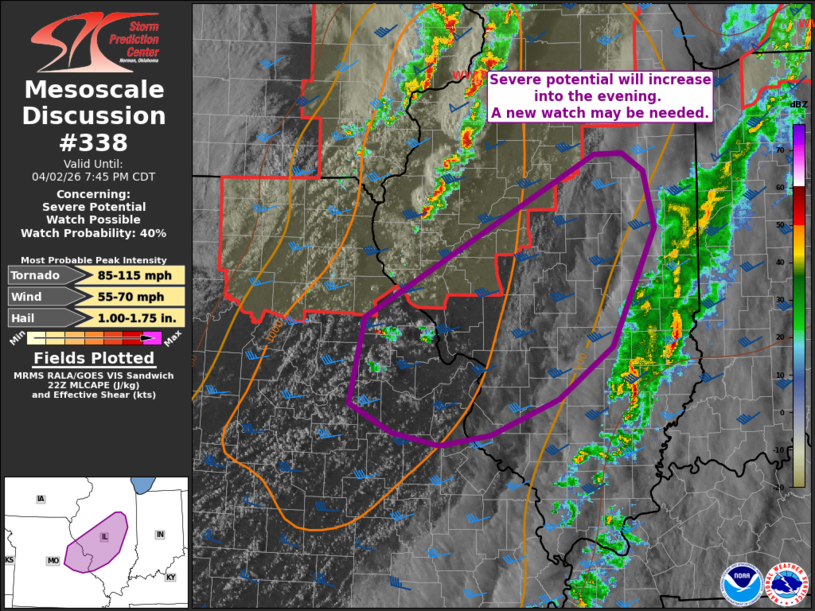
Mesoscale Discussion 0338 NWS Storm Prediction Center Norman OK 0539 PM CDT Thu Apr 02 2026 Areas affected...east-central MO into central IL Concerning...Severe potential...Watch possible Valid 022239Z - 030045Z Probability of Watch Issuance...40 percent SUMMARY...Severe potential will increase/persist into the evening downstream from WW 89 from east-central Missouri into central Illinois. Timing and coverage of storm activity remains uncertain. Trends being monitored for possible watch issuance. DISCUSSION...A few storms have developed and weakened north of I-70 across east-central MO over the past hour. This activity is developing near the surface wind shift/dryline as a dryslot aloft overspreads the region. This is likely suppressing further development/intensification at this time. However, CAMs and WoFS guidance suggest more robust development should occur by 00z near the MS River and into central IL. This airmass has largely recovered from earlier day showers and thunderstorms where clearing has occurred this afternoon. Temperatures have rebounded into the low to mid 70s and dewpoints remain in the 60-64 F range, resulting in a corridor of 500-1000 J/kg MLCAPE. Effective shear magnitudes near 40 kt are noted with stronger, backed low-level winds evident in surface observations across IL, supporting supercell wind profiles. If isolated to scattered storm development can occur and become sustained across this area, damaging wind gusts and a tornado or two will be possible. Timing and convective evolution remains uncertain and trends will be monitored for possible watch issuance sometime in the next few hours. ..Leitman/Smith.. 04/02/2026 ...Please see www.spc.noaa.gov for graphic product... ATTN...WFO...LOT...ILX...LSX... LAT...LON 39309157 40848878 40848845 40688819 40148806 39028857 38548923 38199005 38109067 38219124 38499175 39309157 MOST PROBABLE PEAK TORNADO INTENSITY...85-115 MPH MOST PROBABLE PEAK WIND GUST...55-70 MPH MOST PROBABLE PEAK HAIL SIZE...1.00-1.75 IN |
|
|
Top/All Mesoscale Discussions/Forecast Products/Home |
|
Source link