| Mesoscale Discussion 336 | |
| < Previous MD | |

|
|
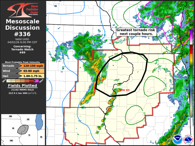
Mesoscale Discussion 0336 NWS Storm Prediction Center Norman OK 0426 PM CDT Thu Apr 02 2026 Areas affected...eastern IA into northwest IL Concerning...Tornado Watch 89... Valid 022126Z - 022300Z The severe weather threat for Tornado Watch 89 continues. SUMMARY...An enhanced corridor of tornado potential will exist across far eastern Iowa into far northwest Illinois over the next couple of hours. DISCUSSION...A robust bowing segment has developed near a surface low across eastern IA. Ahead of this intense line of convection, isolated supercells are noted, with one over Washington County IA having recently produced a spotter-confirmed tornado. Additional cells are developing along the MS River within mid 60s F dewpoints and 0-1 SRH greater than 250 m2/s2. Instability near 1000 J/kg is noted in latest mesoanalysis as a warm front continues to lift northward into southern WI. This corridor will support an enhanced risk of tornado potential over the next couple of hours as storms continue to mature and move northeast. ..Leitman.. 04/02/2026 ...Please see www.spc.noaa.gov for graphic product... ATTN...WFO...LOT...ILX...MKX...DVN...ARX... LAT...LON 41699183 42049154 42299126 42409097 42529064 42559019 42468964 42298947 41908955 41568974 41189006 41049047 41009124 41279190 41699183 MOST PROBABLE PEAK TORNADO INTENSITY...120-150 MPH MOST PROBABLE PEAK WIND GUST...65-80 MPH MOST PROBABLE PEAK HAIL SIZE...1.00-1.75 IN |
|
|
Top/All Mesoscale Discussions/Forecast Products/Home |
|
Source link