| Mesoscale Discussion 327 | |
| < Previous MD | |

|
|
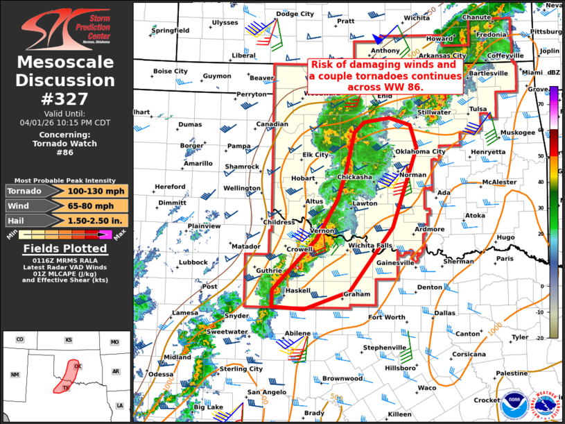
Mesoscale Discussion 0327 NWS Storm Prediction Center Norman OK 0818 PM CDT Wed Apr 01 2026 Areas affected...Parts of central Oklahoma into western North Texas Concerning...Tornado Watch 86... Valid 020118Z - 020315Z The severe weather threat for Tornado Watch 86 continues. SUMMARY...The risk of damaging winds and a couple tornadoes continues across Tornado Watch #86. DISCUSSION...An MCS is tracking slowly eastward across western OK and western North TX, with embedded supercell structures on the southern portion of the line along/south of the Red River. Over the next couple hours, the risk of a couple tornadoes, damaging winds, and large hail should be maximized with the southern storms along/south of the Red River, where unstable inflow and strong low/deep-layer shear (around 300 m2/s2 0-1 km SRH per FDR VWP) is in place. Farther north in western/central OK, a messier convective mode evolution has limited the tornado risk thus far, with primarily a damaging-wind risk. However, the OUN 00Z sounding shows ample surface-based buoyancy/steep lapse rates and a large clockwise-curved hodograph (265 m2/s2 effective SRH) in the pre-convective environment. This could still support embedded mesovorticies/supercell structures with a risk of a couple tornadoes and severe wind gusts toward the I-35 corridor. ..Weinman.. 04/02/2026 ...Please see www.spc.noaa.gov for graphic product... ATTN...WFO...FWD...OUN...SJT... LAT...LON 34289756 33239842 32939933 32979997 33259996 34099909 34779866 35219851 35879833 36049814 36119763 35999720 35609708 34289756 MOST PROBABLE PEAK TORNADO INTENSITY...100-130 MPH MOST PROBABLE PEAK WIND GUST...65-80 MPH MOST PROBABLE PEAK HAIL SIZE...1.50-2.50 IN |
|
|
Top/All Mesoscale Discussions/Forecast Products/Home |
|
Source link