| Mesoscale Discussion 326 | |
| < Previous MD | |
|
|
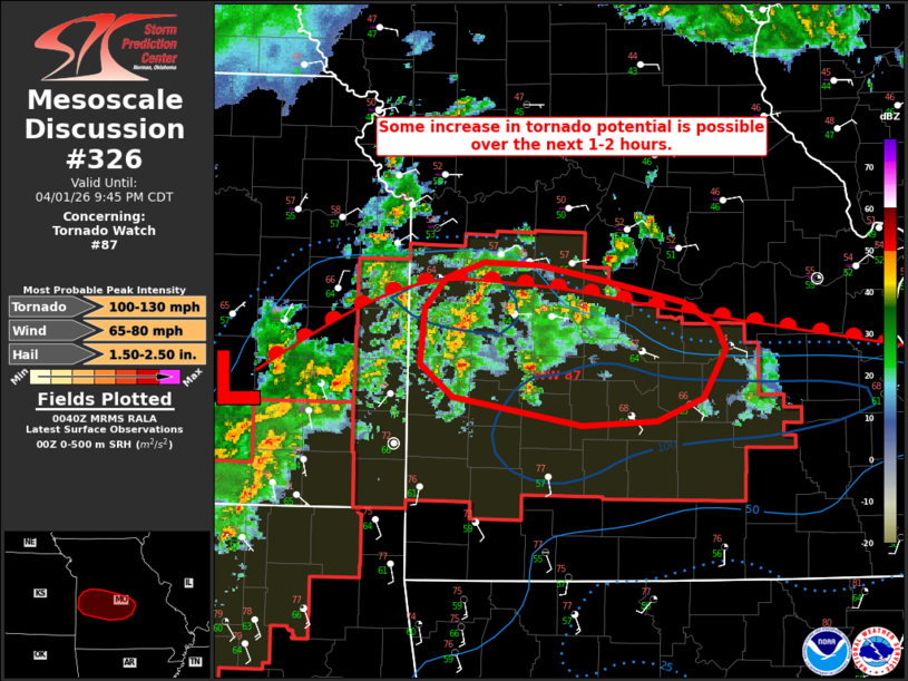
Mesoscale Discussion 0326 NWS Storm Prediction Center Norman OK 0742 PM CDT Wed Apr 01 2026 Areas affected...portions of eastern Kansas into central Missouri Concerning...Tornado Watch 87... Valid 020042Z - 020245Z The severe weather threat for Tornado Watch 87 continues. SUMMARY...At least some increase in tornado risk appears possible over the next 1-2 hours along and south of a surface warm front. DISCUSSION...While nocturnal low-level cooling and weak low-level lapse rates may be tempering overall strengthening, recent convective development has shown some signs of modest intensification across portions of western Missouri during the past 30-60 minutes. Per latest mesoanalysis, 500-1000 J/kg MLCAPE and around 35-40 kts of effective bulk shear should continue to support further strengthening of developing discrete/semi-discrete supercells over the next couple of hours. A corridor of enhanced tornado potential appears possible near and south of a surface warm front across portions of western/central Missouri where backed surface flow, 50-100 m2/s2 0-500 m SRH, and mid-60s F dewpoints are noted via latest mesoanalysis and surface observations. Some uncertainty remains regarding convective evolution given limited strengthening observed thus far and the potential for storms to move north of the surface boundary due to deep-layer flow orientation. Should a supercell or two become better established, however, at least some increase in tornado potential, along with a threat for large hail and severe wind gusts, appears possible over the next 1-2 hours, especially as the nocturnal low-level jet continues to strengthen. ..Chalmers.. 04/02/2026 ...Please see www.spc.noaa.gov for graphic product... ATTN...WFO...LSX...SGF...EAX... LAT...LON 37789422 38019450 38399446 38609427 38729394 38709345 38589286 38449218 38279188 38119181 37769200 37609242 37579307 37789422 MOST PROBABLE PEAK TORNADO INTENSITY...100-130 MPH MOST PROBABLE PEAK WIND GUST...65-80 MPH MOST PROBABLE PEAK HAIL SIZE...1.50-2.50 IN |
|
|
Top/All Mesoscale Discussions/Forecast Products/Home |
|
Source link