| Mesoscale Discussion 308 | |
| < Previous MD Next MD > | |
|
|
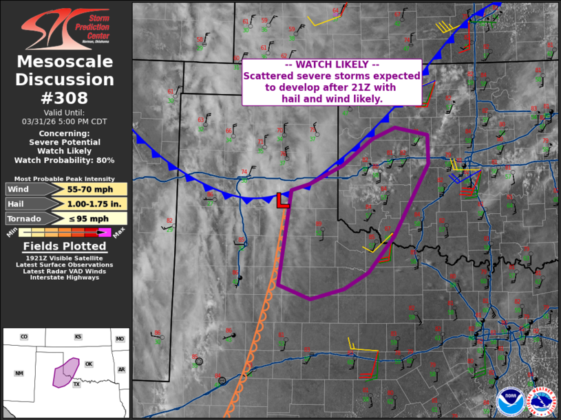
   Mesoscale Discussion 0308
   NWS Storm Prediction Center Norman OK
   0226 PM CDT Tue Mar 31 2026

   Areas affected...parts of the eastern Texas Panhandle and northwest
   Texas into sothwest Oklahoma

   Concerning...Severe potential...Watch likely

   Valid 311926Z - 312200Z

   Probability of Watch Issuance...80 percent

   SUMMARY...Storms are expected to form after 21Z, with large hail and
   locally damaging gusts possible through early evening. A brief
   tornado cannot be ruled out.

   DISCUSSION...Surface analysis shows a cold front moving south across
   western OK and the TX Panhandle, with a dryline extending south from
   the surface low west of KCDS. Temperatures have warmed into the mid
   80s F across the warm sector, with dewpoints holding in the 50s F.
   Given cool midlevel temperatures, this is resulting in a deep layer
   of steep lapse rates. MLCAPE will continue to rise perhaps into the
   1500-2000 J/kg range. Satellite imagery shows CU already beginning
   to form beneath the cirrus as of 1930Z.

   Storms will likely form near the surface low and sporadically
   southward along the dryline into parts of the South Plains after
   21Z. These may be initially high based, but backing and
   strengthening low-level winds will maintain or increase dewpoints
   into the well-mixed boundary layer. The air mass should remain
   sufficiently uncapped into southwest OK and northwest TX to
   sustained any ongoing cells, although capping will become a factor
   after sunset and with eastward extent into the cooler/more moist air
   mass.

   At least for a few hours, slow-moving cells may produce large hail,
   and perhaps a tornado especially near the low or as storms
   potentially propagate east along the sinking cold front. The warm
   air mass and deep mixed layer suggest severe gust potential as well.

   ..Jewell/Hart.. 03/31/2026

   ...Please see www.spc.noaa.gov for graphic product...

   ATTN...WFO...OUN...LUB...AMA...

   LAT...LON   33540111 35030087 35130052 35419990 35829935 36009891
               35889829 35449828 34309894 33749942 33499988 33330050
               33540111

   MOST PROBABLE PEAK TORNADO INTENSITY...UP TO 95 MPH
   MOST PROBABLE PEAK WIND GUST...55-70 MPH
   MOST PROBABLE PEAK HAIL SIZE...1.00-1.75 IN
|
|
|
Top/All Mesoscale Discussions/Forecast Products/Home |
|
Source link