| Mesoscale Discussion 302 | |
| < Previous MD | |

|
|
Mesoscale Discussion 0302
NWS Storm Prediction Center Norman OK
0135 AM CDT Tue Mar 31 2026
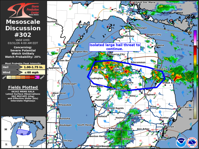
Areas affected...north-central Lower Michigan
Concerning...Severe potential...Watch unlikely
Valid 310635Z - 310800Z
Probability of Watch Issuance...20 percent
SUMMARY...An isolated large hail threat will continue this morning.
DISCUSSION...Several elevated supercells have developed this morning
north of a warm front across north-central Michigan. These storms
are being fueled by around 1000 J/kg MUCAPE within a zone of
moderate deep-layer shear. In addition, strong isentropic ascent is
giving additional support despite the only modest instability. A
broad zone of 60 to 65 knot low-level jet around 1km (as sampled by
LOT/MKX/IWX/DTX VWPs) is supporting the storms north of the front.
As the low-level jet continues to weaken/veer through the overnight
hours, expect these storms to become less intense.
1 and 1.5 inch hail reports have been received thus far and expect
some isolated threat to remain for a bit longer. However, by 9-10Z,
expect any threat to mostly wane.
..Bentley/Mosier.. 03/31/2026
...Please see www.spc.noaa.gov for graphic product...
ATTN...WFO...DTX...APX...GRR...
LAT...LON 44578624 44618548 44398379 44238311 43998300 43718337
43608488 43838628 44068656 44578624
MOST PROBABLE PEAK WIND GUST...UP TO 60 MPH
MOST PROBABLE PEAK HAIL SIZE...1.00-1.75 IN
|
|
|
Top/All Mesoscale Discussions/Forecast Products/Home |
|
Source link