| Mesoscale Discussion 281 | |
| < Previous MD | |
|
|
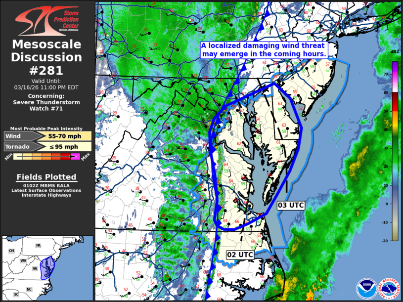
Mesoscale Discussion 0281 NWS Storm Prediction Center Norman OK 0804 PM CDT Mon Mar 16 2026 Areas affected...Portions of the Mid-Atlantic including Washington D.C. Concerning...Severe Thunderstorm Watch 71... Valid 170104Z - 170300Z The severe weather threat for Severe Thunderstorm Watch 71 continues. SUMMARY...A severe squall line will continue to push east/northeast across parts of the Mid-Atlantic over the next few hours and pose a risk for wind damage. DISCUSSION...Radar trends over the past hour have shown a gradual uptick in reflectivity and VIL values as a shallow convective line continues to push into a plume of returning moisture (low 60s dewpoints). The 00z RAOB from IAD sampled 372 J/kg SBCAPE, which while modest, is sufficient for severe convection given ample ascent ahead of the ejecting upper wave and very strong flow just above the surface (50 knot flow within the lowest kilometer). Numerous instances of wind damage have been reported along the line over the past 1-2 hours, as well as observed gusts between 45-55 mph (including a 66 mph gust at Dulles/KIAD). This trend is expected to continue as the line pushes east over the next few hours into a similar thermodynamic and kinematic environment as sampled at IAD. Based on latest storm track estimates, this line should approach the Chesapeake Bay by around 02 UTC and may reach western Delaware by around 03 UTC. ..Moore.. 03/17/2026 ...Please see www.spc.noaa.gov for graphic product... ATTN...WFO...PHI...AKQ...LWX... LAT...LON 36927592 36717639 36597674 36597702 36657718 36777726 37197720 37727727 38257740 38607741 38897729 39147700 39617569 39317528 38697498 38267507 37797531 37307565 36927592 MOST PROBABLE PEAK TORNADO INTENSITY...UP TO 95 MPH MOST PROBABLE PEAK WIND GUST...55-70 MPH |
|
|
Top/All Mesoscale Discussions/Forecast Products/Home |
|
Source link