| Mesoscale Discussion 280 | |
| < Previous MD | |
|
|
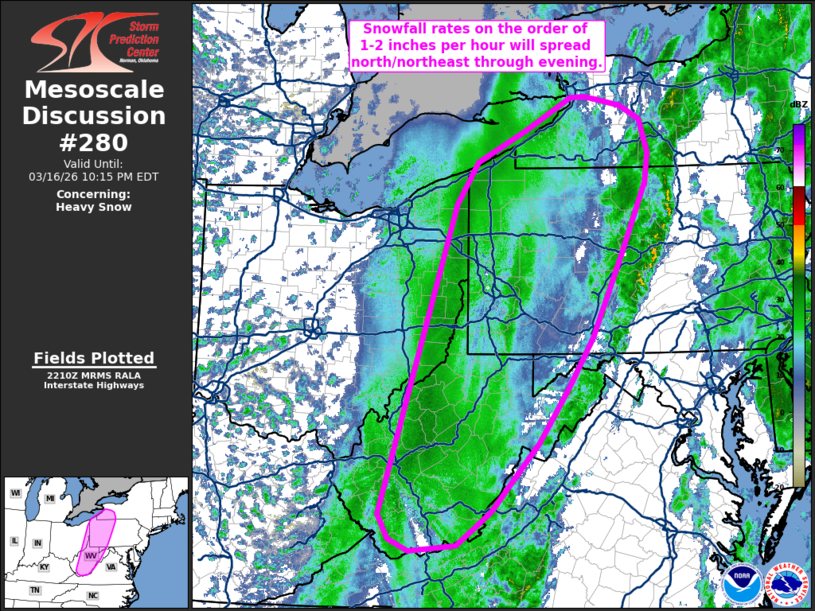
   Mesoscale Discussion 0280
   NWS Storm Prediction Center Norman OK
   0513 PM CDT Mon Mar 16 2026

   Areas affected...West Virginia into far eastern Ohio and western
   Pennsylvania

   Concerning...Heavy snow

   Valid 162213Z - 170215Z

   SUMMARY...A swath of moderate to heavy snow will spread
   north/northeast in the coming hours. Snowfall rates may locally
   increase to 1-2 inches per hour.

   DISCUSSION...Recent regional radar mosaics depict transient bands of
   moderate to heavy snowfall within a broader precipitation shield
   across the central Appalachians/upper OH River Valley. Surface
   observations under the heavier bands have been reporting periods of
   visibility reductions down to 1/4 mile. A broad swath of moderate
   snowfall will be maintained through the evening as ascent within the
   left-exit region of a 120 knot 500 mb jet continues to shift
   northeast. Increasing 850-700 mb frontogenesis will continue to
   overspread the upper OH Valley and provide more focused mesoscale
   ascent favorable for focused snow banding and periods of heavy
   snowfall rates. Although the strongest lift will likely be focused
   within the 850-700 mb layer, ascent through 500 mb will include a
   roughly 100 mb-deep dendritic growth zone. This will also help
   maintain moderate to heavy snowfall rates as surface temperatures
   fall below freezing within the post-frontal air mass. Based on
   latest guidance, snowfall rates over 1 inch/hour appear likely and
   may periodically be as high as 2 inches/hour across portions of PA
   and within the higher terrain of the Appalachians later this
   evening.

   ..Moore.. 03/16/2026

   ...Please see www.spc.noaa.gov for graphic product...

   ATTN...WFO...BGM...BUF...CTP...LWX...RNK...PBZ...RLX...CLE...

   LAT...LON   37458173 37748190 41558069 42078035 42457959 42857884
               42877862 42767804 42597772 42187759 41817765 40927804
               39917851 39297891 38637937 37788014 37378068 37308141
               37458173
|
|
|
Top/All Mesoscale Discussions/Forecast Products/Home |
|
Source link