| Mesoscale Discussion 279 | |
| < Previous MD | |
|
|
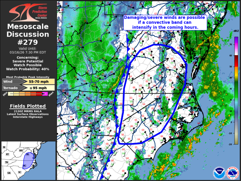
   Mesoscale Discussion 0279
   NWS Storm Prediction Center Norman OK
   0432 PM CDT Mon Mar 16 2026

   Areas affected...North Carolina into portions of the Mid-Atlantic

   Concerning...Severe potential...Watch possible

   Valid 162132Z - 162330Z

   Probability of Watch Issuance...40 percent

   SUMMARY...Shallow convection developing along the primary synoptic
   cold front may reach sufficient intensity for damaging to severe
   winds in the coming hours across North Carolina into the
   Mid-Atlantic. Confidence on how strong convection will be is
   limited, but trends will be monitored for potential watch issuance.

   DISCUSSION...Regional reflectivity imagery shows shallow convection
   developing along the primary synoptic cold front in the lee of the
   Blue Ridge Mountains across portions of western VA and central NC.
   Despite very poor buoyancy immediately downstream (owing to prior
   convective overturning), strong ascent immediately ahead of an
   ejecting mid-level vorticity maximum and within the left-exit region
   of a 120 knot 500 mb jet may provide adequate ascent immediately
   ahead of the front to support shallow convection.

   Regional VWPs across the Mid-Atlantic have shown an uptick in wind
   speeds upwards of 50-70 knots within the lowest kilometer. Wind
   gusts so far within the convective line have been between 35-45
   knots (roughly 40-50 mph); however, if convection can intensify
   further, damaging to severe (50-65 mph) gusts may become more
   prevalent as stronger winds aloft are mixed to the surface via
   convective downdrafts. It remains unclear how intense this
   convection can become in the coming hours - especially with the
   onset of nocturnal cooling/stabilization. Consequently, confidence
   in a severe wind threat is limited, but trends will be monitored for
   the need for watch issuance.

   ..Moore/Gleason.. 03/16/2026

   ...Please see www.spc.noaa.gov for graphic product...

   ATTN...WFO...AKQ...MHX...LWX...RAH...ILM...RNK...

   LAT...LON   34677969 35777947 36747944 37777914 38297863 38527794
               38527752 38407700 38067653 37707624 36907635 35687698
               34987755 34537854 34487907 34487950 34497962 34677969

   MOST PROBABLE PEAK TORNADO INTENSITY...UP TO 95 MPH
   MOST PROBABLE PEAK WIND GUST...55-70 MPH
|
|
|
Top/All Mesoscale Discussions/Forecast Products/Home |
|
Source link