| Mesoscale Discussion 278 | |
| < Previous MD | |

|
|
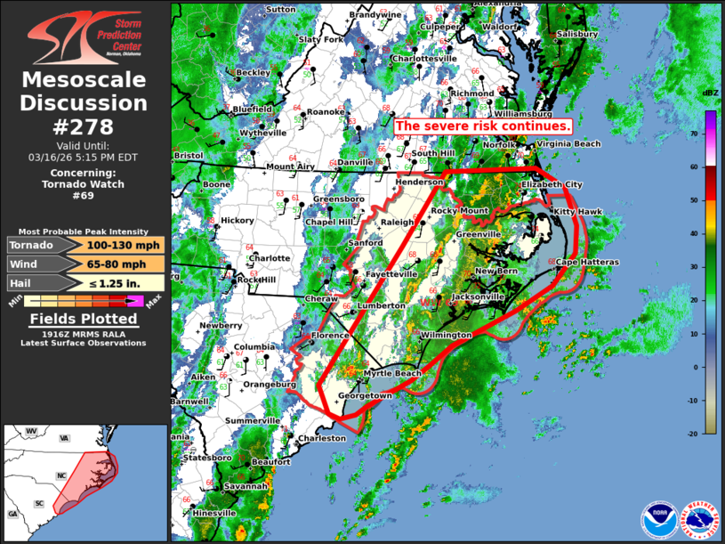
Mesoscale Discussion 0278 NWS Storm Prediction Center Norman OK 0219 PM CDT Mon Mar 16 2026 Areas affected...portions of northeastern South Carolina into central and eastern North Carolina. Concerning...Tornado Watch 69... Valid 161919Z - 162115Z The severe weather threat for Tornado Watch 69 continues. SUMMARY...The risk for damaging gusts and tornadoes continues across WW69. DISCUSSION...As of 1915 UTC, strong thunderstorms were ongoing within a loosely organized convective band from east-central NC to coastal SC. Thus far, numerous storm interactions and weak buoyancy (~500 J/kg MLCAPE 18z MHX Sounding) have limited storm organization. Numerous, but transient, low-level mesocyclones have been observed with embedded convective element this afternoon. Kinematics remain quite strong with 0-1 km shear of 40+ kts. This will continue to pose a risk for damaging gusts and tornadoes with any stronger mesocyclones able to become established. Some clearing as been noted to the west of the primary cluster over central NC. As large-scale ascent from the upper trough moves overhead this afternoon, additional storm development is possible ahead of the cold front. Storm mode is likely to remain mixed/messy with clusters and line segments. Still, the very strong low-level wind fields will support a continued risk for damaging gusts and tornadoes across WW69 this afternoon. ..Lyons.. 03/16/2026 ...Please see www.spc.noaa.gov for graphic product... ATTN...WFO...AKQ...MHX...RAH...ILM... LAT...LON 33597958 35527822 36557751 36607597 36327548 35807529 35427531 34987570 34637633 34157739 33897775 33677806 33317878 33207896 33147922 33207941 33597958 MOST PROBABLE PEAK TORNADO INTENSITY...100-130 MPH MOST PROBABLE PEAK WIND GUST...65-80 MPH MOST PROBABLE PEAK HAIL SIZE...UP TO 1.25 IN |
|
|
Top/All Mesoscale Discussions/Forecast Products/Home |
|
Source link