| Mesoscale Discussion 269 | |
| < Previous MD | |
|
|
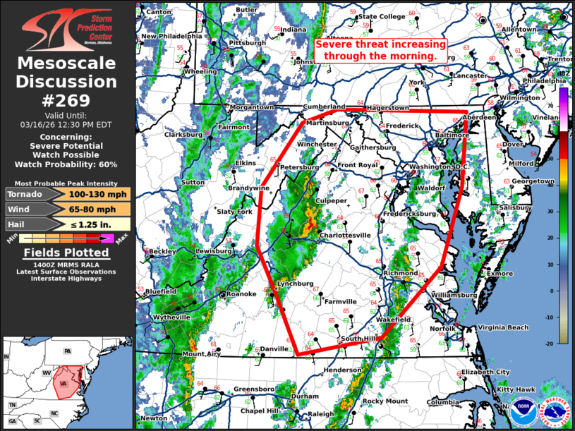
   Mesoscale Discussion 0269
   NWS Storm Prediction Center Norman OK
   0903 AM CDT Mon Mar 16 2026

   Areas affected...Central Virginia into Maryland

   Concerning...Severe potential...Watch possible

   Valid 161403Z - 161630Z

   Probability of Watch Issuance...60 percent

   SUMMARY...The severe weather threat will increase through the
   morning.

   DISCUSSION...Low-level moisture advection and cooling mid-level
   temperatures will continue to destabilize Virginia into Maryland
   this morning. Limited capping evident on the RNK and IAD 12Z RAOBs
   has resulted in scattered warm sector development ahead of the
   primary squall line. These messy-mode storms will continue to limit
   heating, but may have some severe threat as above mentioned
   destabilization continues within a strong wind profile.

   Low-level shear, already strong at 12Z, will continue to strengthen
   through the day. Therefore, any stronger/deeper updrafts could have
   some tornado threat late this morning into the early afternoon. The
   primary threat still appears to be the wind/embedded tornado threat
   later this afternoon as the secondary mid-level jet streak ejects
   east of the Appalachians and wind fields strengthen rapidly.
   However, even this threat is contingent on the evolution of these
   morning storms. A tornado watch will likely be needed at some point,
   potentially by later this morning if the morning storms start to
   show more organization/structure.

   ..Bentley/Thompson.. 03/16/2026

   ...Please see www.spc.noaa.gov for graphic product...

   ATTN...WFO...PHI...AKQ...LWX...RNK...

   LAT...LON   37357914 37957944 38687939 39507874 39677817 39637606
               38697616 37687651 36797746 36587878 37357914

   MOST PROBABLE PEAK TORNADO INTENSITY...100-130 MPH
   MOST PROBABLE PEAK WIND GUST...65-80 MPH
   MOST PROBABLE PEAK HAIL SIZE...UP TO 1.25 IN
|
|
|
Top/All Mesoscale Discussions/Forecast Products/Home |
|
Source link