| Mesoscale Discussion 266 | |
| < Previous MD Next MD > | |
|
|
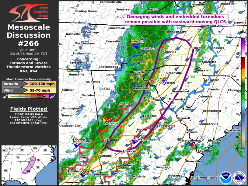
   Mesoscale Discussion 0266
   NWS Storm Prediction Center Norman OK
   0623 AM CDT Mon Mar 16 2026

   Areas affected...western NC and SC into central GA

   Concerning...Tornado and Severe Thunderstorm Watches 63...64...

   Valid 161123Z - 161300Z

   The severe weather threat for Tornado and Severe Thunderstorm
   Watches 63, 64 continues.

   SUMMARY...Damaging winds and some potential for embedded tornadoes
   remain possible with an eastward-moving QLCS.

   DISCUSSION...A NNE/SSW-oriented broken line has shown some recent
   signs of re-intensification as it moves east of the Appalachians.
   Here, a corridor of lower/middle 60s dewpoints is contributing to
   weakly unstable surface-based inflow for this system. Despite the
   marginal buoyancy in place, the strong low/deep-layer flow/shear
   continues to favor damaging winds. Additionally, a few deeper cores
   with mesovortex structure have recently evolved along the southern
   part of the line (where boundary-layer moisture and buoyancy are
   maximized), which could pose a risk of a brief tornado and locally
   enhanced wind damage. This risk should be highest where deep-layer
   shear is oriented oblique to the line (i.e., NNW/SSE-oriented parts
   of the line).

   ..Weinman.. 03/16/2026

   ...Please see www.spc.noaa.gov for graphic product...

   ATTN...WFO...RNK...CAE...GSP...MRX...FFC...

   LAT...LON   35778266 36068247 36178189 36058146 35758118 35208133
               34358176 33698231 32828305 32308363 32118413 32168460
               32298491 32868457 33848355 34308329 34978289 35778266

   MOST PROBABLE PEAK TORNADO INTENSITY...100-130 MPH
   MOST PROBABLE PEAK WIND GUST...55-70 MPH
|
|
|
Top/All Mesoscale Discussions/Forecast Products/Home |
|
Source link