| Mesoscale Discussion 264 | |
| < Previous MD | |
|
|
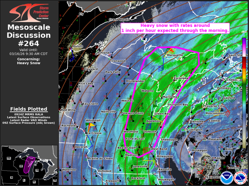
   Mesoscale Discussion 0264
   NWS Storm Prediction Center Norman OK
   0425 AM CDT Mon Mar 16 2026

   Areas affected...Parts of eastern WI and Upper MI

   Concerning...Heavy snow

   Valid 160925Z - 161430Z

   SUMMARY...A swath of heavy snow with rates around 1 inch per hour
   are expected through the morning hours.

   DISCUSSION...Mosaic radar and satellite imagery show an increasingly
   defined deformation zone and inferred strong ascent evolving in a
   north-south corridor extending from parts of Upper MI across eastern
   WI. Here, the GRB 06Z sounding sampled a cold and deeply saturated
   profile, which combined with the strong ascent, will promote heavy
   snowfall rates of 1 to locally 2 inches per hour through the morning
   hours. Additionally, strong surface winds may lead to areas of
   blowing snow and reduced visibility.

   ..Weinman.. 03/16/2026

   ...Please see www.spc.noaa.gov for graphic product...

   ATTN...WFO...APX...MQT...GRB...MKX...

   LAT...LON   43308933 43818944 45628889 46468848 46878784 46888693
               46678579 46278578 45488664 44618732 43878772 43298809
               43078874 43308933
|
|
|
Top/All Mesoscale Discussions/Forecast Products/Home |
|
Source link