| Mesoscale Discussion 258 | |
| < Previous MD | |
|
|
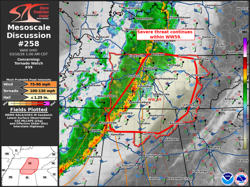
Mesoscale Discussion 0258 NWS Storm Prediction Center Norman OK 1054 PM CDT Sun Mar 15 2026 Areas affected...Middle Tennessee and northern Alabama Concerning...Tornado Watch 59... Valid 160354Z - 160600Z The severe weather threat for Tornado Watch 59 continues. SUMMARY...Severe threat continues within WW59. DISCUSSION...A squall line continues eastward across Middle Tennessee, with history of damaging winds and hail. A cluster ahead of the main line of thunderstorms has exhibited occasional strong rotation and will likely merge with the main line over the next hour. Though moisture remains more marginal, with dew points in the low to mid 50s F and MLCAPE around 250-500 J/kg. Strongly sheared profiles (as observed from the VAD at KBNA) continue to support a strong line of thunderstorms with embedded mesovorticies and potential for damaging wind and tornadoes over the next several hours. ..Thornton.. 03/16/2026 ...Please see www.spc.noaa.gov for graphic product... ATTN...WFO...MRX...FFC...LMK...OHX...BMX...HUN... LAT...LON 34818805 35928712 36428680 36648662 36678612 36648595 36508489 36228480 35778480 35328497 34868517 34408584 34258621 34298716 34298779 34358786 34378796 34818805 MOST PROBABLE PEAK TORNADO INTENSITY...100-130 MPH MOST PROBABLE PEAK WIND GUST...75-90 MPH MOST PROBABLE PEAK HAIL SIZE...UP TO 1.25 IN |
|
|
Top/All Mesoscale Discussions/Forecast Products/Home |
|
Source link