| Mesoscale Discussion 256 | |
| < Previous MD | |
|
|
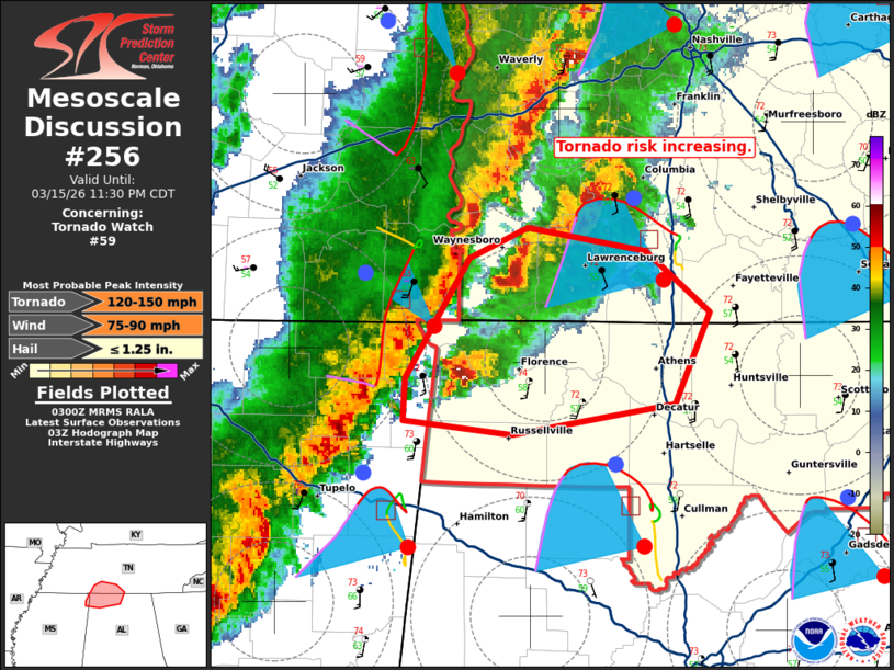
Mesoscale Discussion 0256 NWS Storm Prediction Center Norman OK 1010 PM CDT Sun Mar 15 2026 Areas affected...far northwestern Alabama and south central Middle Tennessee Concerning...Tornado Watch 59... Valid 160310Z - 160430Z CORRECTED FOR TEXT The severe weather threat for Tornado Watch 59 continues. SUMMARY...Tornado risk increasing. DISCUSSION...A discrete supercell has shown persistent rotation and strengthening over the last 30-45 minutes near the TN/AL state line. A second cell has also shown persistent rotation to the north of the TN state line. This is on the southern end of a cluster of cells ahead of the main squall line back to the west on the edge of the 60 F dew points. Within this region, STP around 2 is analyzed in surface objective analysis, with VAD profiles from KBNA and KGWX showing large low-level curvature in hodographs. This corridor will pose a relatively higher risk for tornadoes over the next 1-2 hours given the favorable shear and thermodynamic environment. ..Thornton.. 03/16/2026 ...Please see www.spc.noaa.gov for graphic product... ATTN...WFO...OHX...HUN...MEG... LAT...LON 34758825 35278792 35408763 35298701 35038668 34658686 34528771 34588827 34758825 MOST PROBABLE PEAK TORNADO INTENSITY...120-150 MPH MOST PROBABLE PEAK WIND GUST...75-90 MPH MOST PROBABLE PEAK HAIL SIZE...UP TO 1.25 IN |
|
|
Top/All Mesoscale Discussions/Forecast Products/Home |
|
Source link