| Mesoscale Discussion 252 | |
| < Previous MD | |

|
|
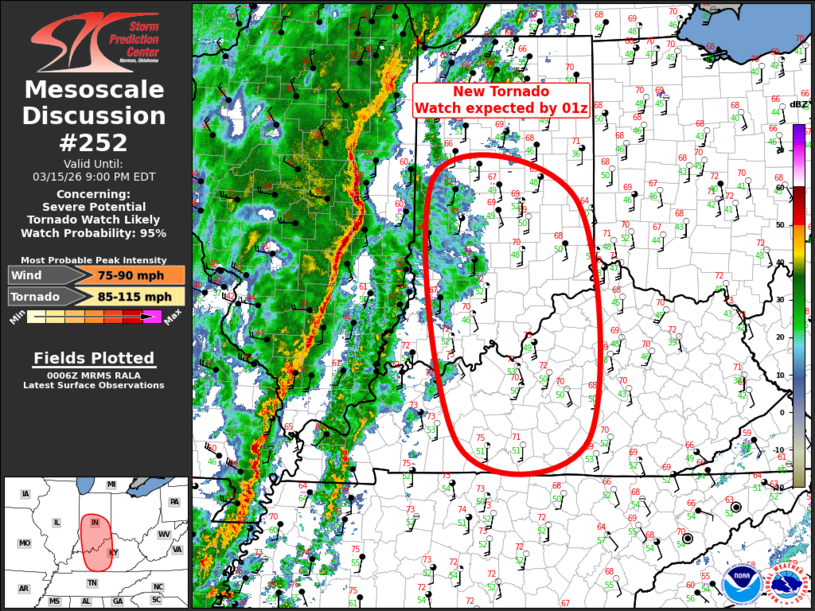
Mesoscale Discussion 0252 NWS Storm Prediction Center Norman OK 0707 PM CDT Sun Mar 15 2026 Areas affected...Central/Southern Indiana into south central Kentucky Concerning...Severe potential...Tornado Watch likely Valid 160007Z - 160100Z Probability of Watch Issuance...95 percent SUMMARY...New Tornado Watch will likely be issued by 01z from portions of central Indiana, south into south central Kentucky. DISCUSSION...Strongly forced squall line, with embedded bows and circulations, is propagating steadily east toward western Indiana. This LEWP appears to have increased its eastward movement to around 35-40kt, and should exit the current watch into west central Indiana by 01z. In advance of the squall line, a roughly 50mi wide band of weak elevated convection has evolved across southeast Illinois into western Indiana. This activity has struggled to attain intensity, but is likely a reflection of the adjusting lapse rates in response to the strong large-scale ascent that is spreading into this region. New Tornado watch will be issued by 01z. ..Darrow/Smith.. 03/16/2026 ...Please see www.spc.noaa.gov for graphic product... ATTN...WFO...ILN...LMK...IND...PAH... LAT...LON 36978684 40108724 39858508 37038492 36978684 MOST PROBABLE PEAK TORNADO INTENSITY...85-115 MPH MOST PROBABLE PEAK WIND GUST...75-90 MPH |
|
|
Top/All Mesoscale Discussions/Forecast Products/Home |
|
Source link