| Mesoscale Discussion 251 | |
| < Previous MD | |

|
|
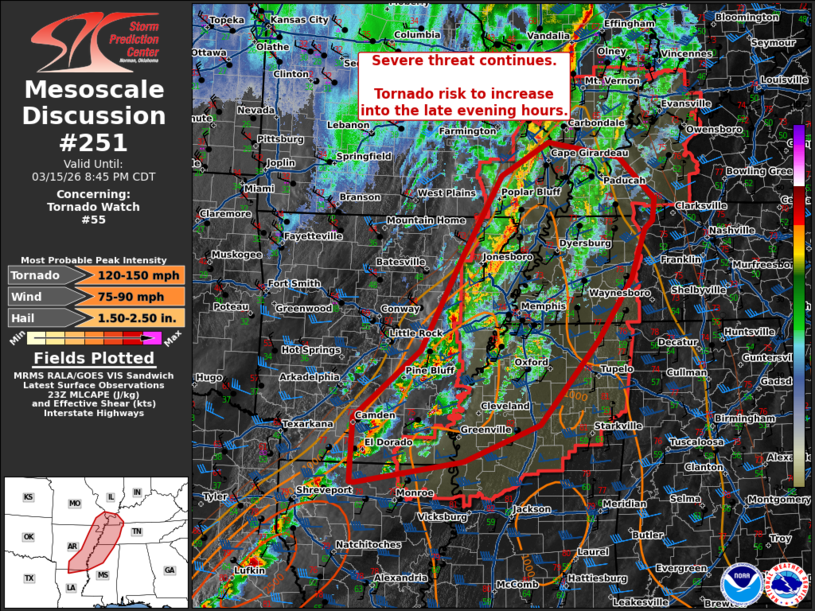
Mesoscale Discussion 0251 NWS Storm Prediction Center Norman OK 0643 PM CDT Sun Mar 15 2026 Areas affected...eastern Arkansas...western Kentucky...western Tennessee...northern Mississippi Concerning...Tornado Watch 55... Valid 152343Z - 160145Z The severe weather threat for Tornado Watch 55 continues. SUMMARY...Threat for damaging wind, large hail, and tornadoes continues within and downstream of WW53 into WW55. DISCUSSION...A broken line of thunderstorms with embedded supercell structures continues eastward through eastern AR and into northern LA. Within the embedded supercells, occasional mesovorticies have been observed in radar. This line continues to move into a favorably unstable and strongly sheared environment across northern Mississippi and western Tennessee. A few semi-discrete supercells have developed ahead of the main line of storms moving north-northeast. Any discrete cell ahead of the front will pose an increased hail and tornado risk. The VAD profile from KNQA (Memphis, TN) shows steadily increasing low-level shear profiles with the strengthening low-level jet. RAP forecasts indicate the LLJ will continue to increase, particularly across northern MS into TN (around 50 kts) over the next few hours. The threat for damaging winds will continue with potential for an increase in the tornado threat as low-level shear continues to increase as low-level hodographs enlarge. ..Thornton.. 03/15/2026 ...Please see www.spc.noaa.gov for graphic product... ATTN...WFO...OHX...PAH...MEG...JAN...LZK...SHV... LAT...LON 32749288 33669283 34609170 35879104 37079033 37558951 37338829 36748767 36438771 36308785 35618809 34758868 33578967 33059097 32739279 32749288 MOST PROBABLE PEAK TORNADO INTENSITY...120-150 MPH MOST PROBABLE PEAK WIND GUST...75-90 MPH MOST PROBABLE PEAK HAIL SIZE...1.50-2.50 IN |
|
|
Top/All Mesoscale Discussions/Forecast Products/Home |
|
Source link