| Mesoscale Discussion 239 | |
| < Previous MD Next MD > | |
|
|
Mesoscale Discussion 0239
NWS Storm Prediction Center Norman OK
0835 PM CDT Sat Mar 14 2026
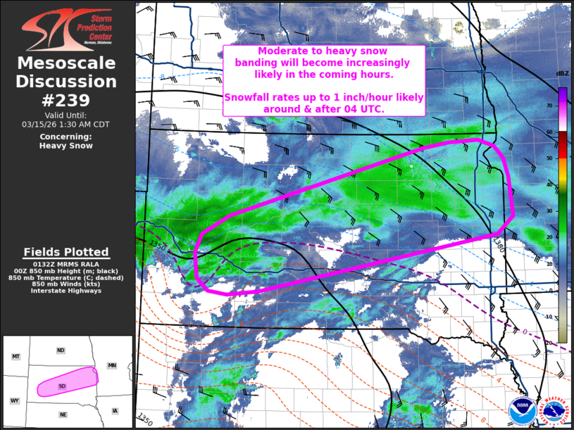
Areas affected...South Dakota
Concerning...Heavy snow
Valid 150135Z - 150630Z
SUMMARY...Bands of moderate to heavy snow are expected to develop
across central to northeast South Dakota in the coming hours.
Snowfall rates upwards of 1 inch/hour appear likely around/after 04
UTC.
DISCUSSION...Steady surface pressure falls are noted across the High
Plains as a cyclone continues to intensify over NE. Concurrently,
925-850 mb frontogenesis is beginning to increase along the NE/SD
border as the warm-frontal baroclinic zone of the developing cyclone
becomes more focused. Additionally, 00z RAOBS and recent VWP
observations along the MO River Valley/eastern Plains are sampling
strong warm advection from the surface to 2-3 km AGL. The
combination of strengthening frontogenesis within a more broad zone
of isentropic upglide should result in the emergence of at least
transient precipitation bands across SD in the coming hours.
Evidence of this banding is already noted in regional reflectivity
data to the east of Rapid City, SD and south of Aberdeen, SD.
With time, ascent within the left-exit region of the approaching
upper jet along with strengthening frontogenesis near 700 mb should
promote more persistent banding and increased ascent through the
dendritic growth zone. The result will be a higher probability for
consistent snowfall rates of 1 inch/hour (possibly higher in
localized areas) under the heavier bands. Based on latest guidance,
the onset of 1+ inch/hour rates may be as early as 02 UTC, but will
become more likely after 04 UTC across central to northeast SD.
..Moore.. 03/15/2026
...Please see www.spc.noaa.gov for graphic product...
ATTN...WFO...MPX...FSD...ABR...UNR...
LAT...LON 44409659 43540161 43490227 43540268 43720291 44110296
44400284 44690225 45739814 45809760 45839696 45749662
45559644 45289634 44679626 44409659
|
|
|
Top/All Mesoscale Discussions/Forecast Products/Home |
|
Source link