| Mesoscale Discussion 238 | |
| < Previous MD | |

|
|
Mesoscale Discussion 0238
NWS Storm Prediction Center Norman OK
0743 PM CDT Sat Mar 14 2026
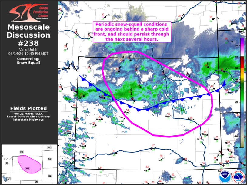
Areas affected...Central to northern Wyoming
Concerning...Snow Squall
Valid 150043Z - 150445Z
SUMMARY...Rapidly falling temperatures, strong winds, and moderate
snowfall behind a sharp cold front are yielding brief
blizzard/snow-squall conditions across north-central Wyoming. These
conditions may persist and spread into central and eastern Wyoming
over the next few hours.
DISCUSSION...Recent radar mosaics show a cold front rapidly pushing
southward to the west of the Big Horn mountains in north-central WY.
Surface observations behind the front have reported temperatures
falling from the low 50s and upper 40s to below freezing within an
hour. Concurrently, strong low-level cold advection (coupled with
strong background gradient winds) is yielding frequent post-frontal
wind gusts of 30-50 mph. This combination of rapidly falling
temperatures, strong wind gusts, and the development of light to
moderate snow showers within the frontal zone is yielding periods of
visibility reductions between 1/2 to 1/4 mile based on regional
ASOS/AWOS reports and web cams.
The cold front is expected to continue pushing south/southeast over
the next several hours as a cyclone continues to intensify to the
east over the High Plains. Light to moderate snow showers will also
spread to the southeast, which may result in a rapid onset of
flash-freeze conditions and sudden visibility reductions under the
heavier snow showers across central to east-central WY where
temperatures are currently above freezing.
..Moore.. 03/15/2026
...Please see www.spc.noaa.gov for graphic product...
ATTN...WFO...UNR...CYS...BYZ...RIW...
LAT...LON 45210878 45230814 45140781 43940477 43640444 43270442
42850457 42630489 42470530 42250587 42190655 42250729
42480785 42680832 42950870 43320906 44170971 44520984
44900976 45140936 45210878
|
|
|
Top/All Mesoscale Discussions/Forecast Products/Home |
|
Source link