| Mesoscale Discussion 237 | |
| < Previous MD | |

|
|
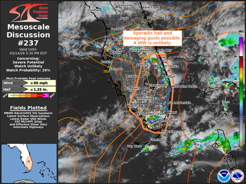
   Mesoscale Discussion 0237
   NWS Storm Prediction Center Norman OK
   0233 PM CDT Sat Mar 14 2026

   Areas affected...portions of the southern Florida Peninsula

   Concerning...Severe potential...Watch unlikely

   Valid 141933Z - 142130Z

   Probability of Watch Issuance...20 percent

   SUMMARY...Scattered thunderstorms ongoing along typical sea breeze
   fronts may briefly organize with the potential for sporadic hail and
   some damaging gusts. A WW is unlikely.

   DISCUSSION...As of 1925 UTC, regional radar and satellite data
   showed scattered thunderstorms had developed and begun to mature
   along typical sea breeze boundary corridors across the southern and
   eastern FL peninsula. Strong surface heating amid upper 60s to low
   70s F surface dewpoints was supporting 1500-2000 J/kg of MLCAPE.
   While deep-layer flow is modest, easterly low-level flow and 180
   degree opposed 20-25 kt winds aloft are supporting sufficient
   deep-layer shear (25-30 kt) for organized multicells and some
   transient supercell structures. Given the storm mode and favorable
   thermodynamics, a few of the stronger cells appear capable of
   sporadic hail. Additionally, high PWAT content could support a few
   stronger downdrafts capable of damaging gusts.

   Current trends and recent CAM guidance suggests convection should
   increase in coverage through this afternoon across the eastern and
   southern parts of the FL Peninsula. Storms may intermittently
   strengthen and weaken with some risk for localized severe weather.
   Given overall storm organization will be transient, the severe risk
   appears isolated enough that a watch will not be needed.

   ..Lyons/Gleason.. 03/14/2026

   ...Please see www.spc.noaa.gov for graphic product...

   ATTN...WFO...MFL...MLB...KEY...TBW...

   LAT...LON   26897991 25948002 25118029 25118068 25278112 25588123
               25908165 26168168 26688143 27768116 27998080 27928029
               27328002 26897991

   MOST PROBABLE PEAK WIND GUST...UP TO 60 MPH
   MOST PROBABLE PEAK HAIL SIZE...UP TO 1.25 IN
|
|
|
Top/All Mesoscale Discussions/Forecast Products/Home |
|
Source link