| Mesoscale Discussion 222 | |
| < Previous MD | |

|
|
Mesoscale Discussion 0222
NWS Storm Prediction Center Norman OK
0345 PM CDT Wed Mar 11 2026
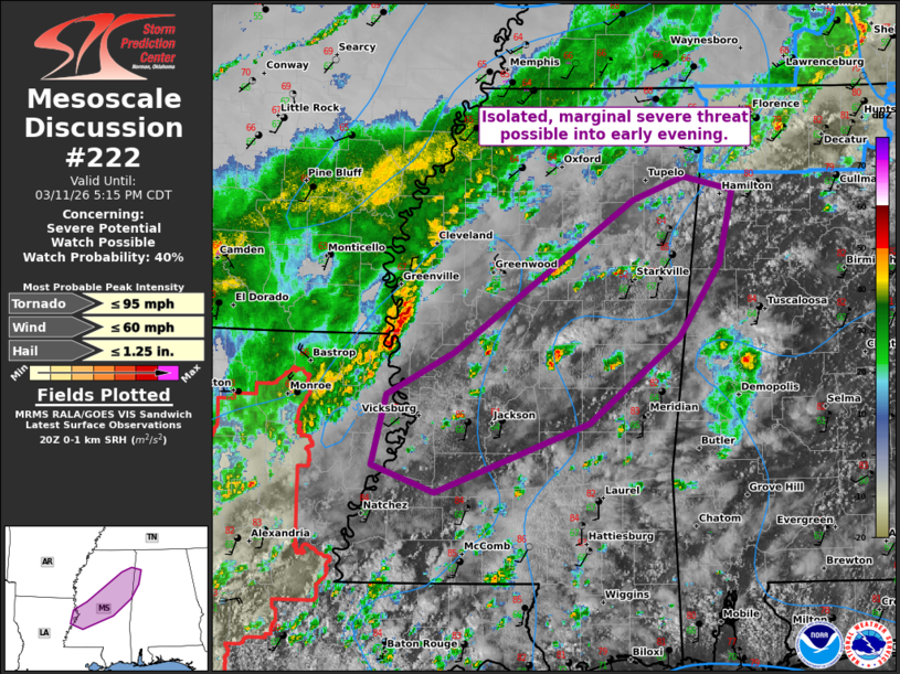
Areas affected...parts of MS
Concerning...Severe potential...Watch possible
Valid 112045Z - 112215Z
Probability of Watch Issuance...40 percent
SUMMARY...An isolated/marginal severe threat is anticipated over the
next 2-3 hours across Mississippi, with greater severe potential
expected later this evening over the southwest portion of the state.
DISCUSSION...Abundant low-topped convection has struggled to deepen,
well downstream of the QLCS over the Sabine Valley and attendant
shortwave trough over east TX. Large-scale outflow continues to sag
southeast from earlier convection that is now in Middle TN, recently
reinforced by upstream convection over the Ark-La-Miss. Sporadic
deepening has occurred with updrafts crossing the sagging outflow.
Despite weak mid-level lapse rates sampled in the 18Z LCH sounding
and 19Z ACARS near MSY, one cell has been able to produce lightning
in the open warm sector northeast of Jackson. With a warm/well-mixed
boundary layer, any sustained deep convection will have the
potential to produce marginal severe wind/hail amid strong
deep-layer shear. Low-level shear is weak per the JAN VWP and should
remain so over the next few hours.
Greater severe potential, mainly in the form of wind and brief
tornado, will likely hold off until later in the evening as the
upstream QLCS over the Sabine Valley approaches southwest MS.
..Grams/Gleason.. 03/11/2026
...Please see www.spc.noaa.gov for graphic product...
ATTN...WFO...BMX...MEG...JAN...
LAT...LON 31729072 31959131 32529118 32869053 34098882 34278834
34178786 33588800 32978839 32298925 31729072
MOST PROBABLE PEAK TORNADO INTENSITY...UP TO 95 MPH
MOST PROBABLE PEAK WIND GUST...UP TO 60 MPH
MOST PROBABLE PEAK HAIL SIZE...UP TO 1.25 IN
|
|
|
Top/All Mesoscale Discussions/Forecast Products/Home |
|
Source link