| Mesoscale Discussion 219 | |
| < Previous MD | |

|
|
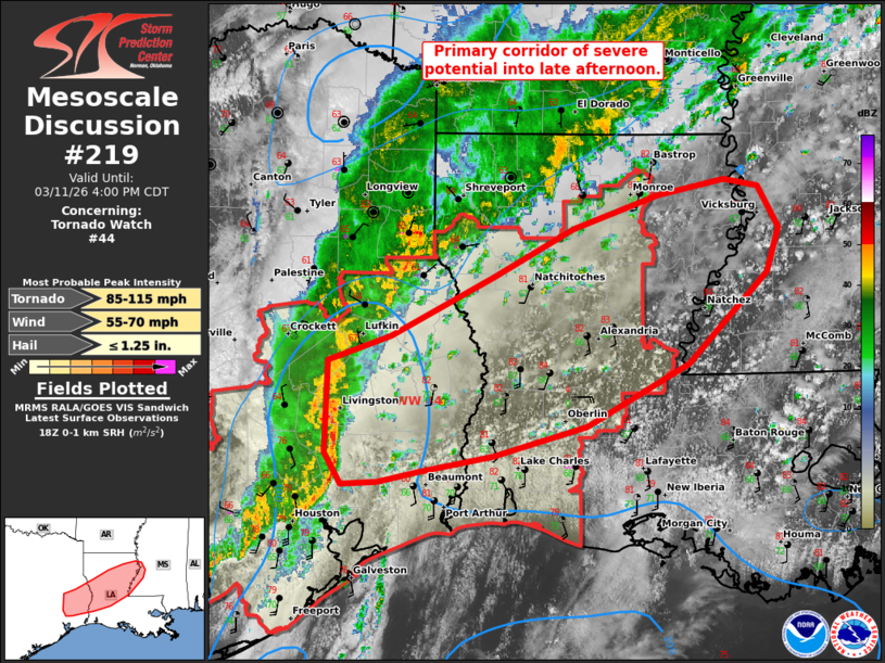
Mesoscale Discussion 0219 NWS Storm Prediction Center Norman OK 0156 PM CDT Wed Mar 11 2026 Areas affected...southeast TX to the Lower MS Valley Concerning...Tornado Watch 44... Valid 111856Z - 112100Z The severe weather threat for Tornado Watch 44 continues. SUMMARY...Primary corridor of severe potential into late afternoon should be across a portion of southeast Texas to the Louisiana/Mississippi border vicinity of the Lower Mississippi Valley. Sporadic damaging winds and a couple tornadoes may yet occur. DISCUSSION...The forward speed of a QLCS across east TX has been modest thus far, with a paucity of measured wind gusts approaching severe magnitudes. The downstream boundary layer remains warm with low to mid 80s surface temperatures common. But as observed by the 18Z LCH sounding, weak mid-level lapse rates have hampered updraft intensity, as well as sustained discrete development ahead of the large-scale outflow. The continued eastward progression of the central TX shortwave trough should support intensification of the QLCS into the late afternoon. Low-level shear will generally remain strong just ahead of the QLCS, mainly across the coastal plain near the Lower Sabine Valley, with weaker values farther inland and east per VWP data/short-term forecast guidance. The compact nature of the cold core near the trough may continue to hamper more robust storm intensities, even with approach of peak boundary-layer heating/depth. ..Grams/Gleason.. 03/11/2026 ...Please see www.spc.noaa.gov for graphic product... ATTN...WFO...JAN...LIX...LCH...SHV...HGX... LAT...LON 31109505 31319444 31829345 32219267 32509184 32629119 32569087 32229066 31849079 31089155 30569254 30319345 30189415 30109457 30079491 30339507 31109505 MOST PROBABLE PEAK TORNADO INTENSITY...85-115 MPH MOST PROBABLE PEAK WIND GUST...55-70 MPH MOST PROBABLE PEAK HAIL SIZE...UP TO 1.25 IN |
|
|
Top/All Mesoscale Discussions/Forecast Products/Home |
|
Source link