| Mesoscale Discussion 218 | |
| < Previous MD | |
|
|
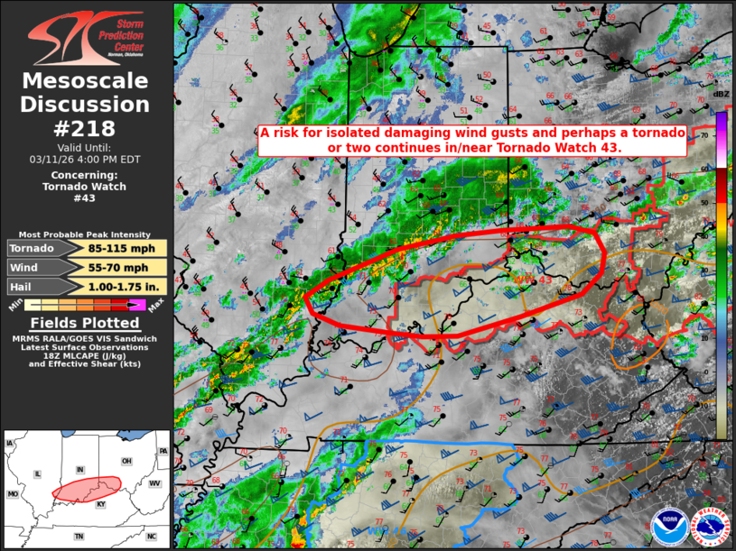
Mesoscale Discussion 0218 NWS Storm Prediction Center Norman OK 0136 PM CDT Wed Mar 11 2026 Areas affected...portions of the lower and middle Ohio River Valley Concerning...Tornado Watch 43... Valid 111836Z - 112000Z The severe weather threat for Tornado Watch 43 continues. SUMMARY...Thunderstorms will continue to pose a risk for damaging wind gusts and perhaps a tornado or two across portions of northern Kentucky and southern Indiana into southwestern Ohio over the next couple of hours. DISCUSSION...Thunderstorm redevelopment is ongoing across portions of the middle Ohio River Valley as filtered diurnal heating has coupled with dewpoints near 60 F to yield weak to modest buoyancy in the wake of morning convection. While poor lapse rates aloft are limiting instability to 500-750 J/kg MLCAPE, strong effective bulk shear of 50+ kts continues to support at least some organization of developing convection, including a broken band of thunderstorms across southeastern Illinois and southern Indiana. It remains uncertain how long this band may persist as increasing high cloud cover is likely to limit any further destabilization. However, latest guidance continues to suggest that at least a few line segments and/or discrete cells will persist eastward across WW0043. Despite limited buoyancy, strong 850 mb flow (50+ kt at 1 km AGL per the VWX/LWX VWP) continues to support strong speed shear and elongated hodographs in the low levels. Thus, at least some potential for isolated damaging wind gusts and perhaps a tornado or two appears possible over the next 1-2 hours. ..Chalmers/Gleason.. 03/11/2026 ...Please see www.spc.noaa.gov for graphic product... ATTN...WFO...JKL...ILN...LMK...IND...PAH...ILX... LAT...LON 38128759 38278803 38488816 38728778 38958714 39138664 39308569 39378491 39418379 39328338 39068322 38818328 38538361 38268461 38008565 37998623 38058679 38128759 MOST PROBABLE PEAK TORNADO INTENSITY...85-115 MPH MOST PROBABLE PEAK WIND GUST...55-70 MPH MOST PROBABLE PEAK HAIL SIZE...1.00-1.75 IN |
|
|
Top/All Mesoscale Discussions/Forecast Products/Home |
|
Source link